

E3SM Diagnostics

An example of the polar contour plots for precipitation rate

An example of 2d joint histogram plot using COSP simulator output

An example of the zonal mean surface air temperature line plot
The goal of this comprehensive diagnostics software is to serve as an essential E3SM tool to facilitate the development of the next-generation earth system model. This package is embedded into the E3SM process flow to enable a seamless transition between model runs and diagnostics.
- fully integrates the functionality of NCAR’s AMWG diagnostics package.
- utilizes most updated observational datasets, including remote sensing, reanalysis, and in-situ datasets.
- interfaces with diagnostics developed from different E3SM focus groups: atmosphere group, coupled simulation group, land group.
- interacts effectively with the PCMDI’s metrics package and the ARM diagnostics package.
- is flexible for user-specified diagnostics and is configured for use by other earth system models.
- enables model versus model and observational data versus observational data comparison in addition to standard model versus observational dataset.
E3SM Diagnostic Package Documentation
- E3SM Diagnostics GitHub repo: https://github.com/E3SM-Project/E3SM_diags
- Full Documentation: https://e3sm-project.github.io/e3sm_diags/
Diagnostic Plot Types and Currently Available Analysis Datasets
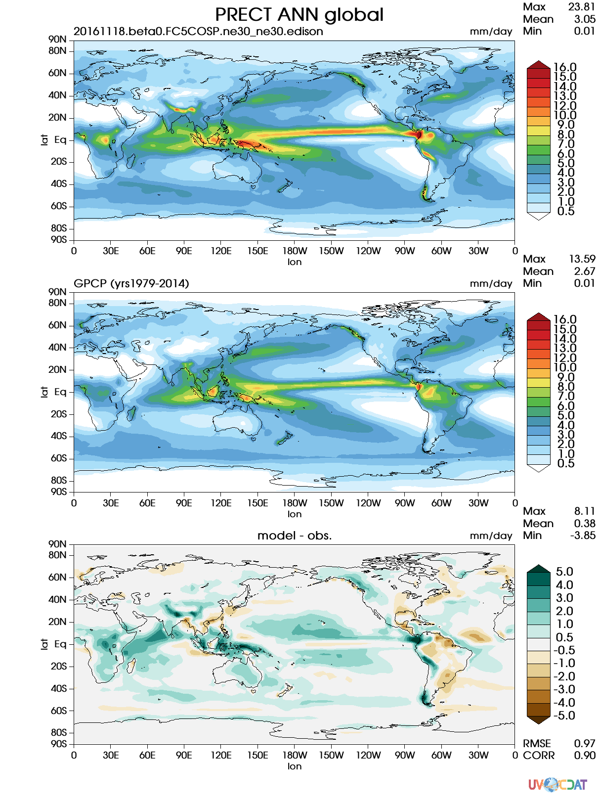
An example of the lat-lon contour plots for global precipitation
The software provides support for diagnostics based on seasonal or annual climatology data, including:
- Latitude-Longitude contour maps
- Polar contour maps
- Zonal mean line plots
- Pressure-Latitude zonal mean contour
- CloudTopHeight-Tau joint histograms
- Tables summarizing metrics
- Taylor Diagrams for spatial variability
A basic set of analysis datasets are established for earth system fields:
- GPCP for Precipitation
- CERES_EBAF for radiation
- Hadley Center data for sea surface temperature
- WHOI-OAFlux for ocean surface latent and sensible heat fluxes
- ERA-Interim and MERRA2 for reanalysis datasets
- ISCCP, MISR and MODIS for Satellite simulator datasets
More datasets and variables can be easily extended based on scientists’ requests.