

v2 Water Cycle Research
The v2 water cycle research and experiments examine the hydrological cycle and its sensitivity to model resolution and radiative forcings. They address the science question:
V2 SCIENTIFIC QUESTION:
What are the relative impacts of global forcing versus regional effects of human activities on flood and drought in North America?
Floods and droughts are often perceived as natural hazards, but perturbations of the Earth system by human activities may alter their characteristics, with important consequences to energy production and use. Broadly, global forcing and warming due to large-scale perturbations of the atmospheric composition and land use land cover may increase atmospheric moisture holding capacity and increase flood risk by increasing the frequency and intensity of heavy precipitation. On the other hand, a general increase in evaporation with warmer temperatures may reduce soil moisture and increase drought risk. At the same time, regional effects from land use and water use such as crop production, irrigation, and water management—as well as plants’ response to the global forcing—may perturb the local surface water balance to influence floods and droughts at basin and subbasin scales.
In catchments across the U.S., flooding can be attributed to different flood generation mechanisms including extreme rainfall events, rainfall in excess of the soil moisture storage capacity, snowmelt, and rain-on-snow events (Berghuijs et al., 2016). Hence, regional flood trends may differ depending on the dominant response of different flood-generating mechanisms to changes in the environments. Changes in storm rainfall and antecedent soil moisture can also change flood seasonality (Ye et al., 2017), with a more variable timing of flooding presenting larger challenges for flood protection. The catchment response may also be significantly altered by water management through reservoir operations to dominate changes in flood risk in basins with large reservoir storage capacity (Wang et al., 2017).
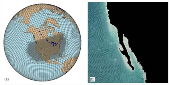
Schematics of possible North American RRM configurations for the (a) atmosphere and (b) ocean
In North America, drought is attributable to the atmospheric responses to sea surface temperature anomalies in the tropical and coastal oceans (Hoerling and Kumar 2003; Gentemann et al., 2017). Once initiated, land-atmosphere interactions can play an important role in sustaining or intensifying droughts (Hong and Kalnay, 2002; Schubert et al., 2004). Climate models project unprecedented drought risks in the Southwest and Central Plains in response to warming (Seager et al., 2007; Cook et al., 2015). Concurrent heat waves and droughts have become more frequent in the U.S. since the 1960s (Mazdiyasni and AghaKouchak 2015). As temperatures continue to rise, the reduction of snowpack and increase in evapotranspiration may give rise to more frequent “hot droughts” such as the California drought between 2012 and 2015 (Overpeck, 2013; Swain et al., 2014). Hydrological droughts can also be exacerbated by local water extraction from streams (Wan et al., 2017) and groundwater depletion (AghaKouchak et al., 2015) to meet increasing water demand.
To predict changes in flood and drought risks in the Anthropocene, Earth system models must consider the combined global and regional effects of human activities on water cycle processes. Using an RRM configuration with higher resolution over North America and the coastal ocean and including new capabilities for modeling water use and management, E3SM will be used to investigate how large-scale and regional perturbations by human activities may alter floods and droughts and to explore the potential emergence of novel flood and drought regimes along with their physical mechanisms.
With a regional focus over North America, the E3SM V2 science campaigns will leverage DOE BER investments across several programs such as the Atmospheric Radiation Measurement (ARM) and Atmospheric System Research (ASR) programs with long term observations of atmospheric processes and surface fluxes in the Southern Great Plains and Alaska, the Next Generation Ecosystem Experiment in the Arctic (NGEE-Arctic) supported by the terrestrial ecosystem science program with measurements and modeling of terrestrial ecosystem processes in the pan-Arctic region of North America, and the Regional and Global Modeling and Analysis (RGMA) program that has been supporting the development of metrics and diagnostics to advance understanding of the water cycle and biogeochemical processes and extreme events. E3SM will benefit from the BER programs’ contributions in measurements to constrain modeling, as well as in model development, evaluation, and analysis and diagnostics tools.