

Science & Technical Highlights

Machine Learning Helps Improve Groundwater Representation in Earth System Models
Calibration of groundwater table depth revealed tradeoffs in runoff, soil moisture, and land–atmosphere feedbacks ...
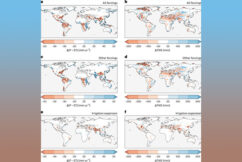
Expanding Irrigation Increases Regional Land Water Depletion
Irrigation growth altered water balance across agricultural regions ...
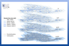
Watershed-Based Representation Discretized into Topographic Units Better Captures Land Surface Heterogeneity
Watershed-based discretization better captured multiscale variability ...
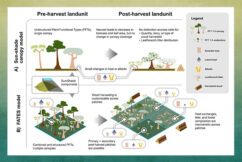
Vegetation demography plays a crucial role in the effects of wood harvesting on the land surface properties
Wood harvest demography boosts E3SM’s realism for albedo and surface fluxes ...
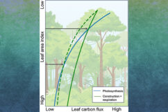
Field-based Canopy Gradients in Leaf Respiration Improve Canopy Structure in the ELM-FATES Demography Model
Updated leaf respiration modeling boosts forest simulation accuracy in E3SM ...

Using Machine Learning to Map Transformation Rates of Dissolved Organic Carbon in Rivers
ML mapping of soil-to-river carbon flow across the US improves Earth system model accuracy ...
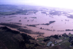
Future Flood Extremes from Rain-on-Snow Events Face Change
Extreme rain-on-snow flood events show varied future risks, urging region-specific planning ...

Improving River Flow Modeling Using Unstructured Meshes in Earth System Models
Unstructured mesh method matches traditional river models and improves river network accuracy ...

Efficient Stormwater Network Representation Improves Urban Flood Modeling
New model improves urban flood prediction and guides smarter stormwater infrastructure planning ...

Drivers and Impacts of Sediment Deposition in Amazonian Floodplains
Modeling shows dam, deforestation impacts in high resolution ...
Earth System Changes Affect Future Agricultural Productivity in the Midwest
Shifts in temperature and rainfall affect crops in Midwest ...

Linking Water and Carbon Cycles Across Landscapes
New method boosts plant productivity estimates, aiding predictions ...

How Global Expansion of Irrigation Influences Moist-Heat Stress
Irrigation boosts humidity, worsening moist-heat stress ...

Probabilistic Projections of Sea-Level Contribution from a Stable Antarctic Ice Sheet Sector
Beyond 2100, high greenhouse gas emissions are likely to lead to rapid retreat of Amery Ice Shelf ...

Uncovering the Substantial Predictability of the 2003 European Summer Heatwave Linked to the Tibetan Plateau
Tibetan Plateau land surface conditions can enhance subseasonal-to-interannual predictions of European heatwaves ...