

Watershed-Based Representation Discretized into Topographic Units Better Captures Land Surface Heterogeneity
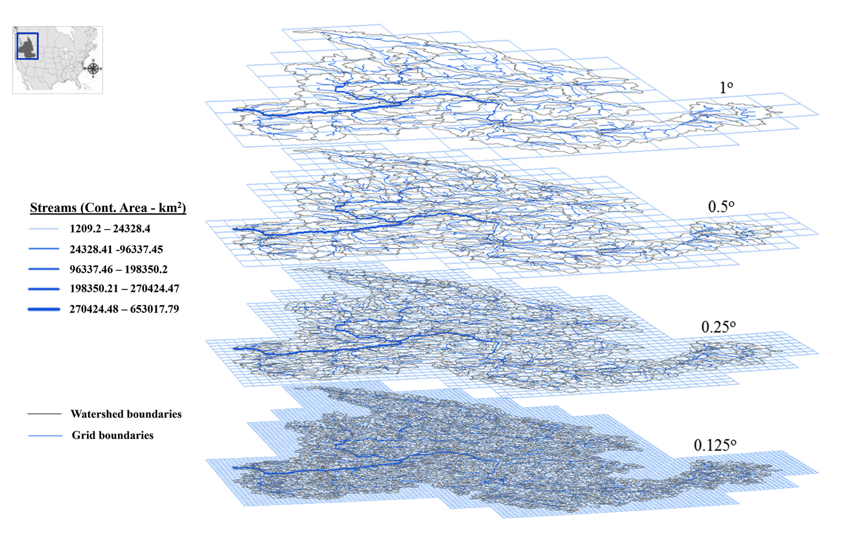
Figure 1. Perspective view of the regular grid- and watershed-based representations across four spatial scales, taking the Columbia River Basin as an example.
Watershed-based representation discretized into topographic subgrid units better captured small-scale land cover, precipitation, temperature, and snow variability across multiple spatial scales.
The Science
Earth system models (ESMs) often divide land into large grid cells, but real landscapes vary over short distances as a result of differences in topography, vegetation, and weather patterns. This makes it difficult to represent important small-scale land surface variability that influences runoff, snow accumulation, and energy exchange.
The Impact
Across spatial scales, this study found that watershed-based topography-based subgrid units (TGUs) (Fig. 1) better represented patterns in topographic slope, vegetation cover, and hydrometeorology compared with grid-based TGUs, although the two approaches performed similarly for elevation. When evaluated against site observations at the finest spatial scale, watershed-based TGUs better matched observed precipitation, temperature, and snow water equivalent at most SNOwpack TELemetry (SNOTEL) sites, indicating potential advantages of watershed-based subgrid structure for improving model realism and evaluation. These findings show that watershed-based land discretization can improve how ESMs represent realistic land surface variability without requiring high grid resolution. This approach can also improve how land model performance is evaluated using site observations and help strengthen simulations of snow, water, and land-atmosphere interactions, supporting more realistic land surface representation in ESMs.
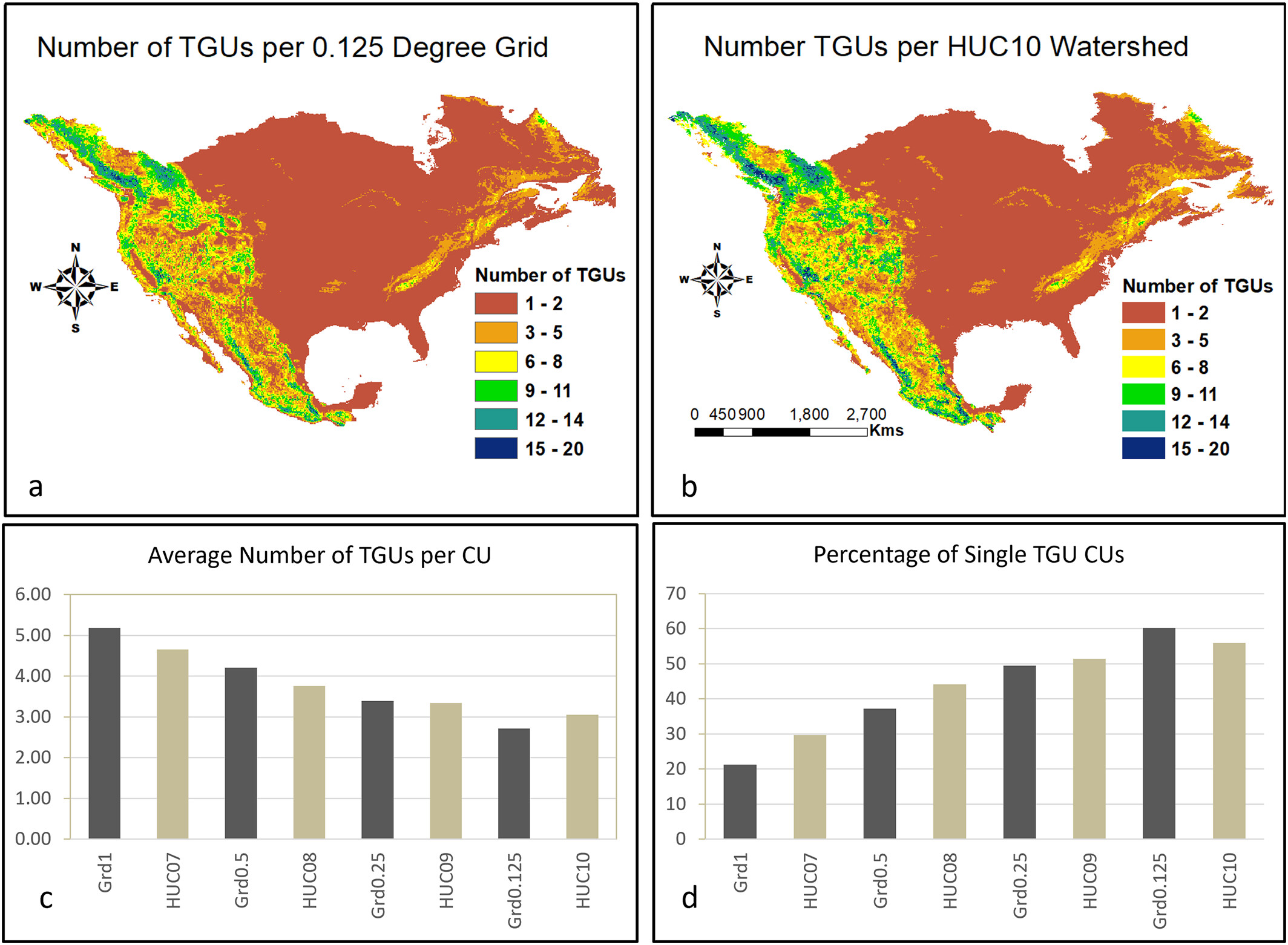
Figure 2. Number of topographic units (TGUs) across multiple spatial scales of the grid-based (Grd1, Grd0.5, Grd0.25, and Grd0.125) and watershed-based (HydroBASINS levels 07-10, here marked as HUC, which more typically denotes the similar Hydrologic Unit Codes) representations. Comparison of the spatial pattern of the number of TGUs per grid (a) and per watershed (b) at the finest spatial scales (Grd0.125 and HUC10). Average number of TGUs per grid and per watershed (computational units) at four spatial scales (c) and the percentage of grids and watersheds with a single TGU (d). Topography-based subgrid structure improves representation of land surface heterogeneity by subdividing grid-based and watershed-based model units into terrain-informed TGUs across scales.
Summary
This study evaluated how well two land discretization approaches — the use of grid- and watershed-based computational units — captured land surface heterogeneity when each was further discretized into TGUs. These were derived across the continental United States at four comparable spatial scales (1°, 0.5°, 0.25°, 0.125° for grid-based, HydroBASINS levels 07-10 for watershed-based) using consistent parameters and assessed using statistical metrics for elevation, slope, vegetation cover (normalized difference vegetation index, NDVI), and surface hydrometeorological variables (precipitation, air temperature, and snow water equivalent) (Fig. 2). The results showed that watershed-based TGUs were more consistent at capturing heterogeneity linked to slope, land cover, and surface hydrometeorology across spatial scales, while both approaches were similar for elevation. This improved capability reflects the combined effects of watershed-based computational units and TGU-level discretization.
Publication
- Tesfa, T. K., Leung, L. R. & Duan, Z. Land surface heterogeneity captured by topography-based subgrid structures in grid-based and watershed-based computational units. J. Adv. Model. Earth Syst. 18, e2025MS005101 (2026). https://doi.org/10.1029/2025MS005101
Funding
- This research is supported by the Office of Science of the Department of Energy as part of the Earth System Model Development program area through the Energy Exascale Earth System Model (E3SM) project. Pacific Northwest National Laboratory is operated by Battelle for the Department of Energy under contract DE-AC05-76RL01830. The reported research used the Department of Energy’s Biological and Environmental Research Earth System Modeling program’s COMPY computing cluster, located at Pacific Northwest National Laboratory. The authors thank the two reviewers for their insightful comments, questions, and suggestions. Notice: This manuscript was authored by Battelle Memorial Institute under contract DE-AC05-76RL01830 with the Department of Energy.
Contact
- L. Ruby Leung, Pacific Northwest National Laboratory
This article is a part of the E3SM “Floating Points” Newsletter, to read the full Newsletter check:
- E3SM Floating Points, May ’26: Looking Forward to the Summer All-Hands
