

Improving River Flow Modeling Using Unstructured Meshes in Earth System Models
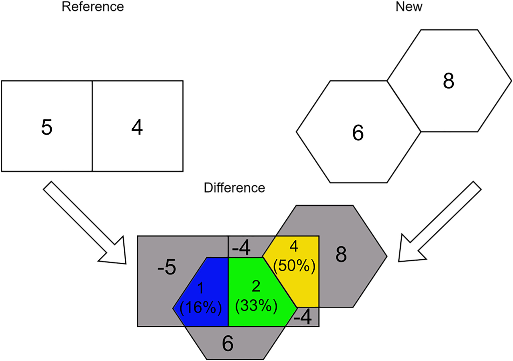
Figure 1. Illustration of the mesh-independent polygon-based spatial data comparison. The references and new mesh variables are on the top left and right. The bottom plot shows the absolute and relative differences between these two. Numbers represent variable values or absolute differences (relative differences: diff(a,b)/max(a,b) in parentheses). For example, the blue section has an absolute difference of 6-5=1 and a relative difference of (6-5)/max(5,6)=1/6=16%. Gray polygons represent differences where there is no overlap. Colored polygons represent differences where meshes overlap. Only colored polygons are meaningful for comparison.
New approach offers comparable performance to traditional models, while overcoming the latter’s limitations.
The Science
Earth system models (ESMs) simulate river flow using Cartesian rectangular meshes (structured methods). These meshes have several limitations, especially when coupled with unstructured mesh-based ocean components, since these have no regular pattern and linking the two can be challenging (Fig. 1). The rectangular meshes also lack utility for regionally refined meshes (RRMs).
The Impact
This research addresses the limitations of traditional rectangular meshes in ESMs by integrating an unstructured mesh approach that offers comparable performance while better representing river networks and enhancing model coupling (Fig. 2). This innovation allows for RRMs in river components, a critical advancement for Earth system research. It also reduces uncertainties and maintains model assumptions across different scales. This work enables more seamless integration of rivers with other Earth system components like oceans, benefiting fields such as hydrology and oceanography.
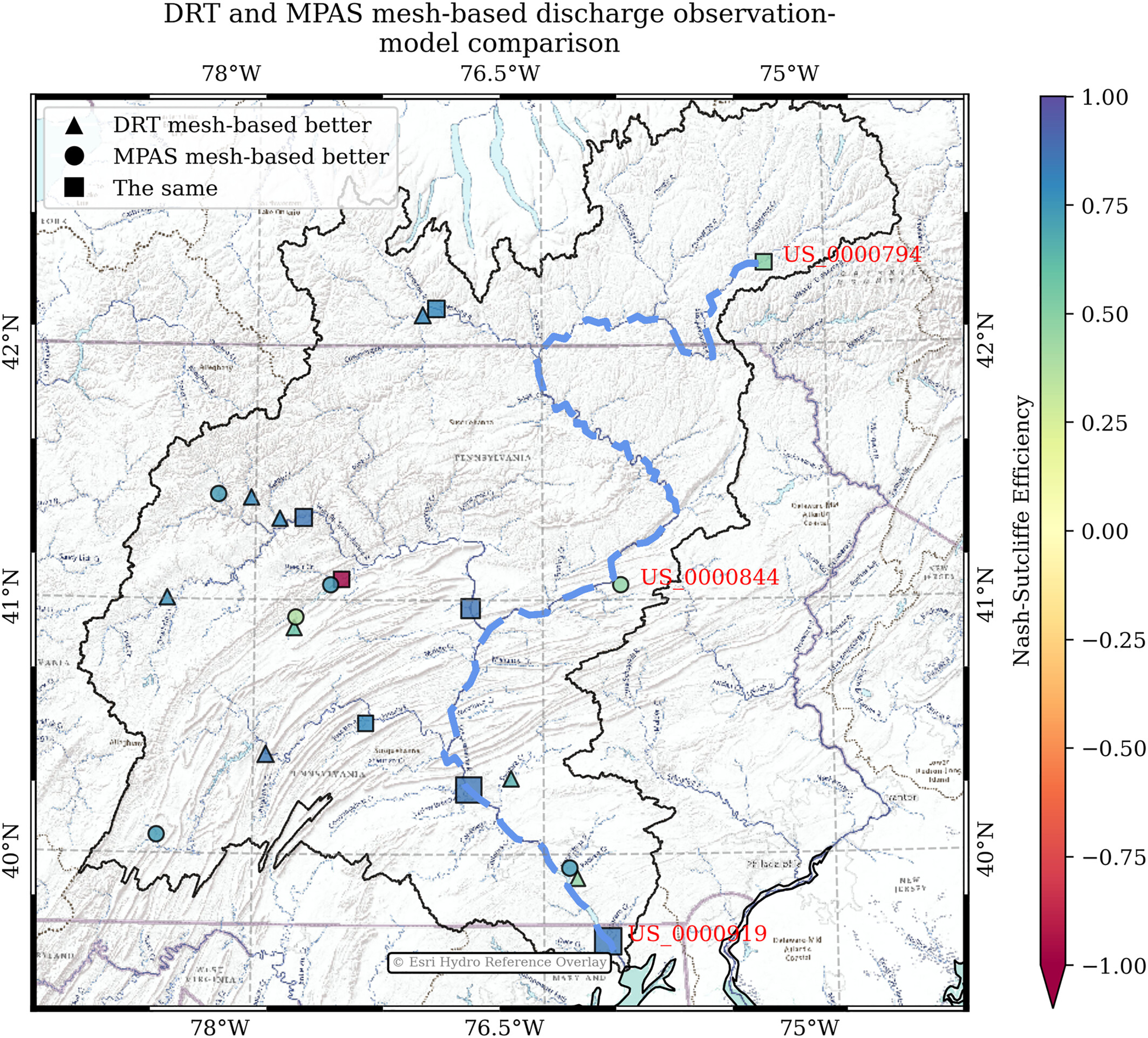
Figure 2. Nash–Sutcliffe efficiency (NSE) comparison based on time series Global Streamflow Indices and Metadata (GSIM) archive datasets and model simulations in the Susquehanna River basin. Triangles, circles, and squares represent gauge stations where Dominant River Tracing (DRT) mesh (Cartesian rectangular mesh) or MPAS mesh (unstructured mesh)-based simulations outperform or are equal to the other simulations. The stations with red labels are used for time series and profile analysis. The gauge stations’ icons are scaled by the drainage area. The black line is the basin boundary. The dashed blue line is used to extract river discharge and water depth along the main channel. The base images are Esri terrain overlayed by the hydrologic datasets. Image from Liao et al. (2025).
Summary
This study integrated a new type of unstructured Voronoi mesh into the Energy Exascale Earth System Model (E3SM)’s river component, Model for Scale Adaptive River Transport (MOSART). The model’s simulation of river discharge and water depth was evaluated across Arctic, temperate, and tropical watersheds. Results show that the unstructured approach performs similarly to structured methods, with differences typically less than 10 percent while better representing complex river networks. Unstructured meshes offer advantages like improved representation of complex river networks and coastlines, along with better coupling with other Earth system components and more effective mesh evaluation. While the unstructured approach shows great potential, further improvements in numerical methods are needed to fully utilize its benefits in hydrologic and Earth system modeling.
Publication
- Liao, C., Xu, D., Cooper, M. G., Zhou, T., Engwirda, D., Tan, Z., et al. (2025). Evaluation of flow routing on the unstructured Voronoi meshes in Earth system modeling. Journal of Advances in Modeling Earth Systems, 17, e2024MS004737. https://doi.org/10.1029/2024MS004737
Funding
- This research was funded as part of the multi-program, collaborative Integrated Coastal Modeling (ICoM) project and the Interdisciplinary Research for Arctic Coastal Environments (InteRFACE) project through the Department of Energy, Office of Science, Biological and Environmental Research program, Earth and Environment Systems Sciences Division, Earth System Model Development (ESMD) program area.
Contact
- Chang Liao, Pacific Northwest National Laboratory
- Zeli Tan, Pacific Northwest National Laboratory
- Robert Hetland, Pacific Northwest National Laboratory