

NGD Coastal Waves
Simulation of Coastal and Cross-Component Earth System Model Processes via Waves
E3SM Next Generation Development for Coastal Waves
WAVEWATCH III® is being introduced into the Energy Exascale Earth System Model (E3SM) to advance coastal processes within E3SM. Currently, wind wave processes occurring at subgrid scales are not represented by the ocean model. Simulation of ocean waves will allow for improved sea levels during hurricanes. Wave, ocean, and sea ice interactions in the marginal ice zone are needed to properly simulate waves in high-latitudes and will better represent wave erosional fluxes to land-fast ice and continental ice shelves in order to better represent cryosphere contributions to global and regional sea level rise.
Background
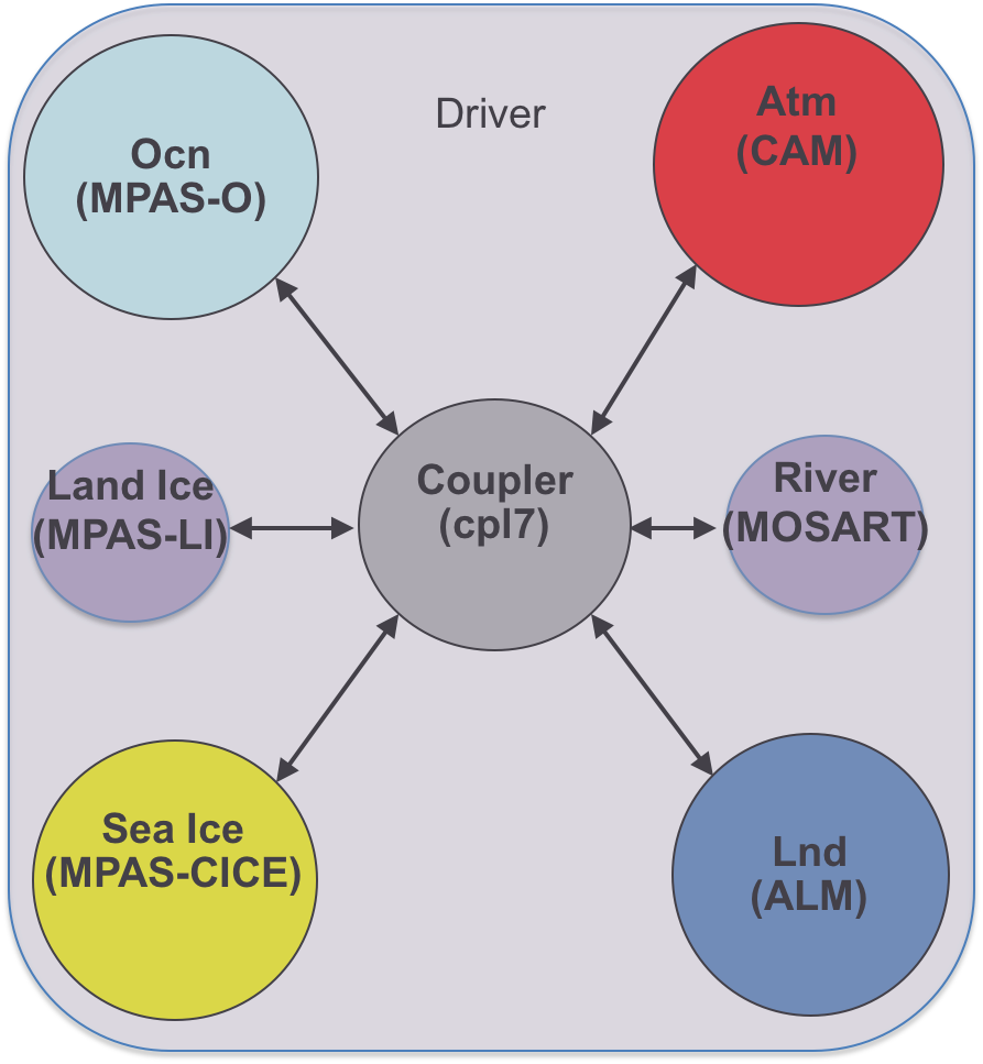
Figure 1. Existing E3SM model components.
The Exascale Energy Earth System Model (E3SM) is composed of a variety of physical and biogeochemical dynamical systems, or model components. These components include atmosphere, ocean, sea ice, land, land ice, and river models joined via a coupler and driver (Figure 1). Each of these models is rich in their representations of physical processes. However, simulation of cross-component interactions require representation of additional processes not contained within each of the individual models.
A key process that is not currently represented is ocean waves. Ocean waves are forced by both the atmosphere and ocean and are modulated by sea ice, land ice, and land interactions, especially in coastal areas. This mini-Next General Development (NGD) focuses on introducing coastal wave modeling capabilities into E3SM to directly simulate ocean waves and their cross-component interactions. An existing unstructured grid wave model, WAVEWATCH III® (WW3, Tolman, 2009), is being incorporated into E3SM and cross-component couplings are being developed for specific science applications.
Simulating Regional Sea Level Rise and Coastal Inundation
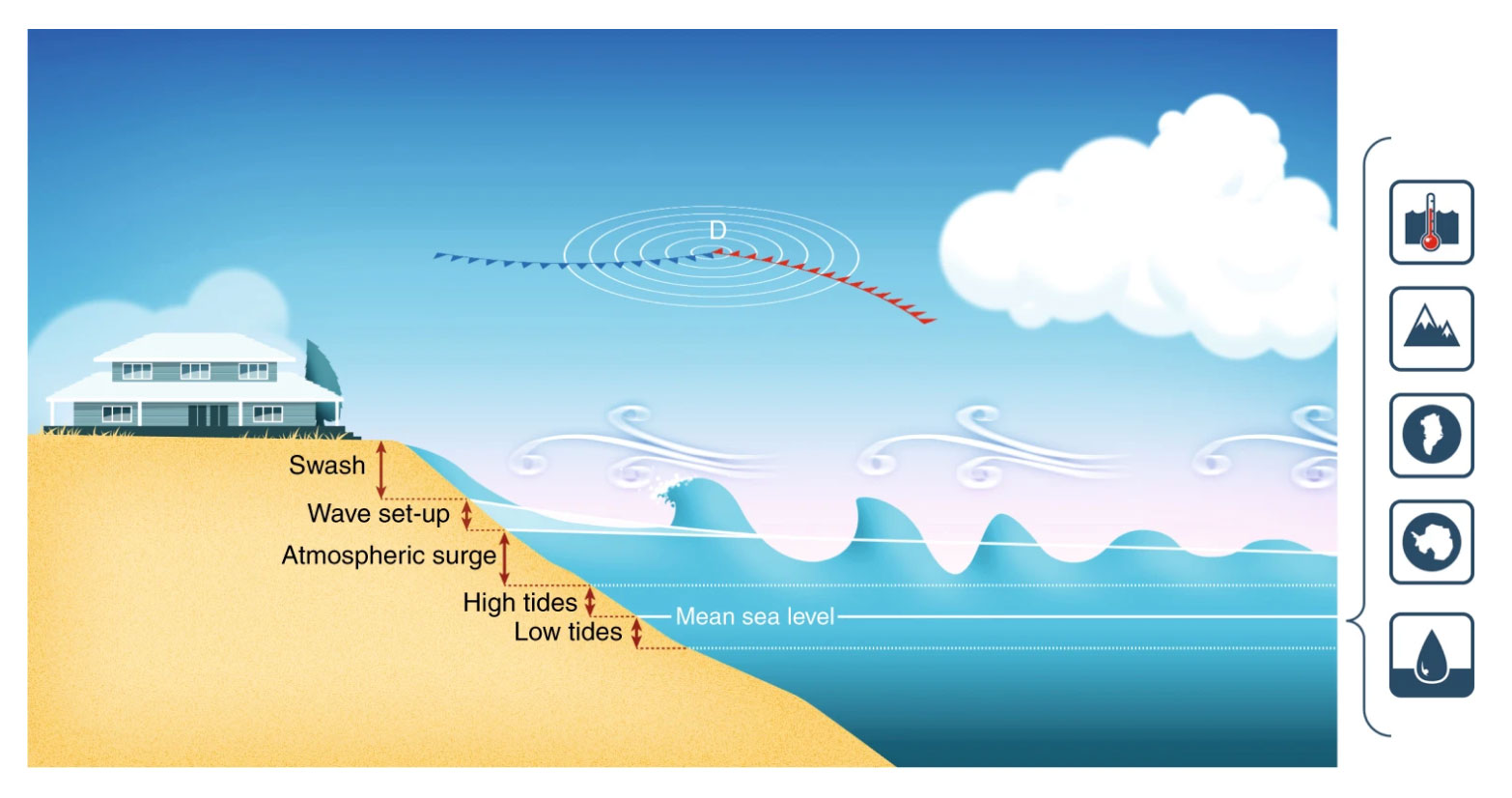
Figure 2. Contributions to coastal inundation, including wave set-up due to wave breaking at the coast (Melet et al., 2018). Icons on right hand side from top to bottom correspond to (1) steric sea level rise due to ocean thermal expansion and regional sea level rise due to ocean circulation; transfer of water from land to ocean due to mass loss from (2) glaciers and from the (3) Greenland and (4) Antarctic ice sheets, as well as from (5) land water storage changes, for example, due to changing land use where the level of vegetation affects the amount of moisture stored on the land.
Simulation of regional sea level rise and coastal inundation to address E3SM v3/v4 science drivers (Figure 2) requires the addition of several key coastal ocean processes that are currently missing in E3SM.
Regional sea level rise, which sets the rate of baseline inundation, is already simulated in part via the existing global ocean circulation. However, storm surges are fast time-scale and episodic coastal ocean processes that modify inundation via forcing by localized pressure systems and wind. Wind forcing is responsible for both large-scale resolved motions in the ocean ranging from basin-scale currents to coastal upwelling, which are currently resolved in MPAS-O, and small-scale wind waves. A sub-grid wave model is needed because the ocean model is unable to resolve wind waves at Earth System Model scales. These wind waves break in shallow coastal areas, and coupled ocean-wave simulation is needed to resolve these processes. Figure 3 shows the length and time scales of waves in the Earth System and how WAVEWATCH III is used to represent wind-wave effects that are at sub-grid scale resolutions within E3SM (wavelengths shorter than 1000 m and wave periods less than 30 seconds). For example, wind waves, swell, wave-wave interactions, and wave breaking must be directly simulated in WaveWatch III. Wave-current interactions, via radiation stresses, contribute to both increasing and decreasing severity of flooding via set-up and set-down of the storm surge (Figure 2). The video above shows a WAVEWATCH III simulation capturing the 2005 hurricane season, and highlights the capability of waves to be simulated under tropical cyclones.
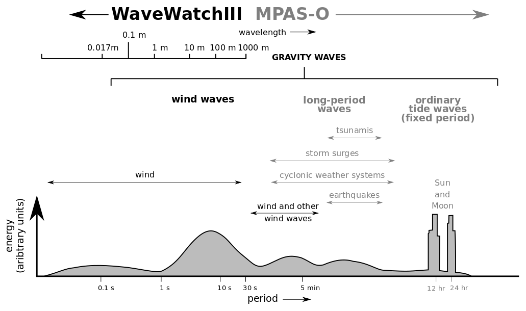
Figure 3. Scales of motions in the ocean from small, coastal scales (left side of schematic) to global ocean scales (right side of schematic). WAVEWATCH III is needed to simulate wind waves that cannot be directly resolved using MPAS-O at wavelength scales smaller than 1000m (Figure adapted from Wright et al., 1999).
Simulating the Marginal Ice Zone

Figure 4. Wave and sea ice interactions in the marginal ice zone Adapted from Dai et al. (2019) and Sutherland and Dumont (2018). Waves are attenuated as they propagate through the sea ice zone. They contribute to the dynamics, growth, and melt within the pack, impacting established sea ice most obviously via changes to the floe size distribution, which is the size distribution of plates of ice that give a cracked eggshell appearance to the pack. Moving from left to right in the figure, waves interact with and contribute to frazil ice which is produced by cooling ocean water. Frazil is aggregated to a point where ice reaches a maximum concentration and local sections of ice raft on top of each other to produce thick ice that eventually congeals into solid blocks of sea ice past an equilibrium point. Wave properties, including reflection, damping, and production due to wind fetch over open waters are modified throughout this process.
New wave, ocean, and sea ice interactions within the marginal ice zone (Figure 4) are needed in order to accurately simulate high-latitude coastal processes as the marginal ice zone serves as the buffer between the open ocean and sea ice pack, land-fast ice, and land ice. Wave and sea ice interactions in the marginal ice zone modify wave directions and amplitude and help reduce the erosional energy that contributes to land-fast ice and continental ice shelf melt, a key contributor to sea level rise (Figure 1). Thus, the marginal ice zone ultimately aids in limiting sea level rise. Accurate simulation of marginal ice zone processes, particularly wave and sea ice interactions, are therefore essential to understanding global coastal processes.
A key focus of this NGD effort is evaluation of WAVEWATCH III’s accuracy in high-latitude regions (e.g., the Southern Ocean as shown in Figures 5 and 6). Development of coupling to MPAS-O and MPAS-Seaice provides an improved capability to begin to understand and represent wave and marginal ice zone dynamics that modify high-latitude cryosphere dynamics. Figure 6 shows an assessment of Southern Ocean biases using a WAVEWATCH III simulation against observational data collected remotely via altimeters. In the video, wave simulation results are shown for the Southern Ocean to illustrate the potential to improve marginal ice zone simulation by understanding and modeling wave, current, and ice interactions in high-latitudes.
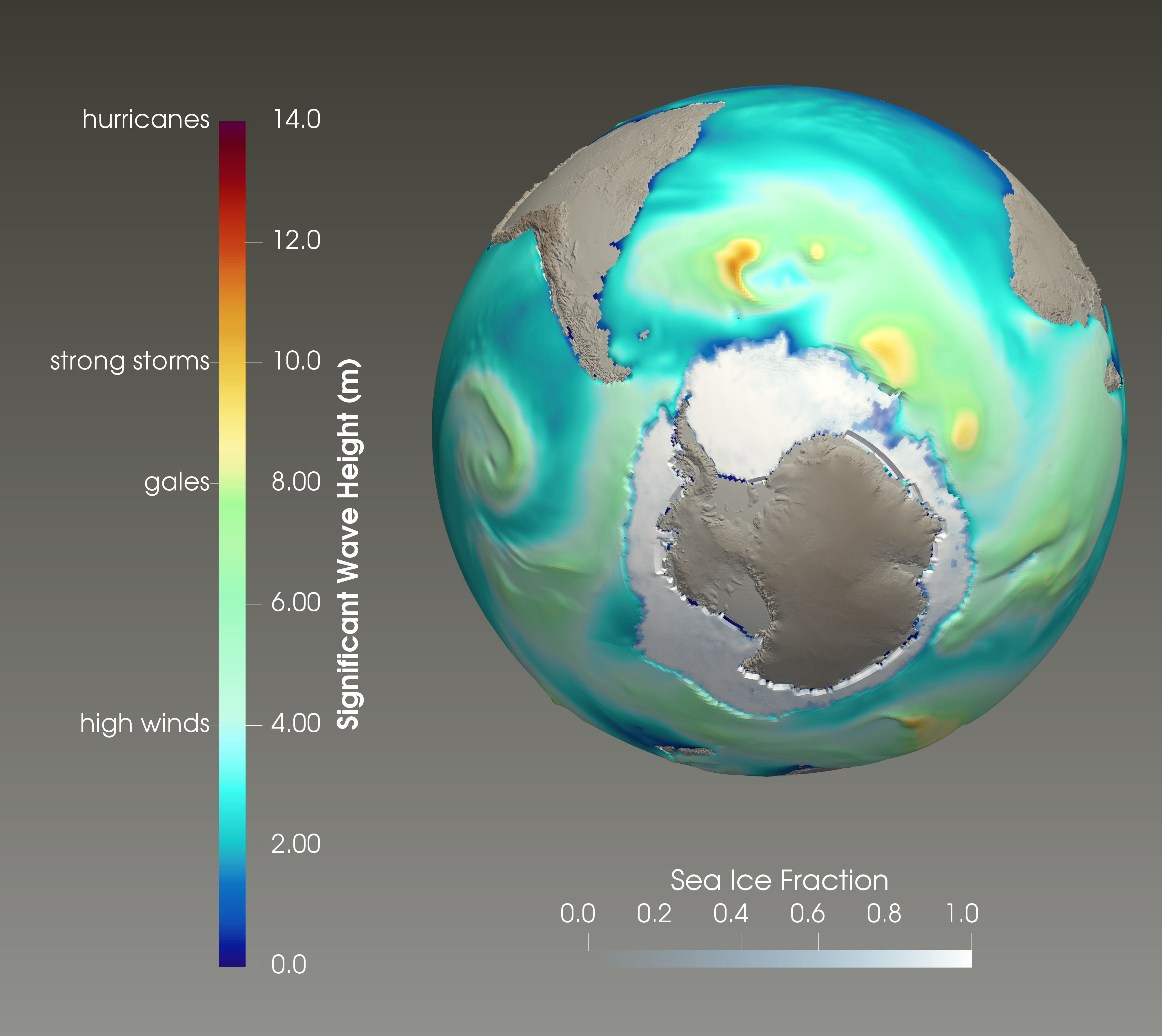
Figure 5. WAVEWATCH III Southern Ocean simulation showing significant wave height with sea ice extent and distribution, where the extent of sea ice inhibits formation and propagation of waves.
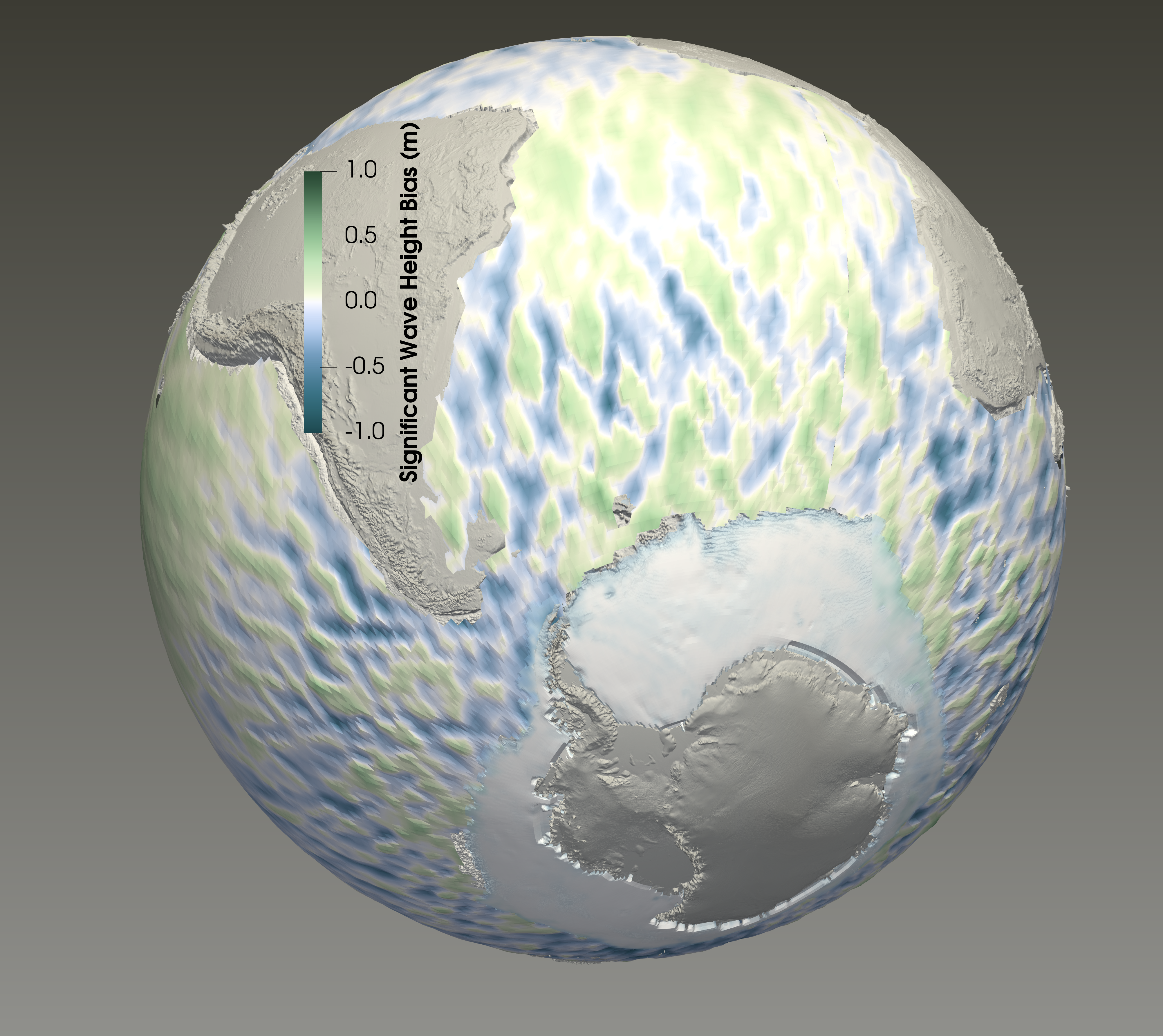
Figure 6. Significant wave height bias between aggregated altimeter observations and model results over one month, including high-latitude coverage for the Southern Ocean. Visible stripes in the bias are due to aliasing by non-uniform altimeter satellite tracks.
Future Advantages
Looking to future Earth System Model applications, waves and their coupled interactions span a variety of additional Earth System Model components and processes. For example, waves strongly affect coastal sediment transport and vegetation at shorelines to modify the coastal landscape via coupled ocean-land processes that will need to be simulated on decadal timescales in order to accurately represent feedbacks of Earth System Model evolution on regional sea level rise and coastal inundation. Further, waves modulate fluxes of mass and energy between the ocean and atmosphere. Sea surface wave conditions also modify the sea surface albedo (white-capped waves increase albedo while smooth seas decrease it) and they have a direct effect on future warming and ocean-atmosphere interactions. Thus, incorporation of WaveWatch III into E3SM provides an unparalleled opportunity to resolve processes at the interfaces between components (e.g., ocean, sea ice, atmosphere, land, and land ice) that are essential to understand coastal change and coupled Earth System dynamics.
References
- Dai, Hai-Jin, James C. McWilliams, and Jun-Hong Liang. “Wave-driven mesoscale currents in a marginal ice zone.” Ocean Modelling 134 (2019): 1-17. https://doi.org/10.1016/j.ocemod.2018.11.006
- Li, Q., Webb, A., Fox-Kemper, B., Craig, A., Danabasoglu, G., Large, W. G., & Vertenstein, M. (2016). Langmuir mixing effects on global climate: WAVEWATCH III in CESM. Ocean Modelling, 103, 145-160. http://dx.doi.org/10.1016/j.ocemod.2015.07.020
- Melet, A., Meyssignac, B., Almar, R., & Le Cozannet, G. (2018). Under-estimated wave contribution to coastal sea-level rise. Nature Climate Change, 8(3), 234.
- Sutherland, Peter, and Dany Dumont. “Marginal ice zone thickness and extent due to wave radiation stress.” Journal of Physical Oceanography 48.8 (2018): 1885-1901. https://doi.org/10.1175/JPO-D-17-0167.1
- Tolman, H. L. (2009). User manual and system documentation of WAVEWATCH III® version 3.14. Technical note, MMAB Contribution, 276, 220.
- Wright, J., Colling, A., & Park, D. (Eds.). (1999). Waves, tides and shallow-water processes (Vol. 4). Gulf Professional Publishing.