E3SM Simulation Campaigns Continue

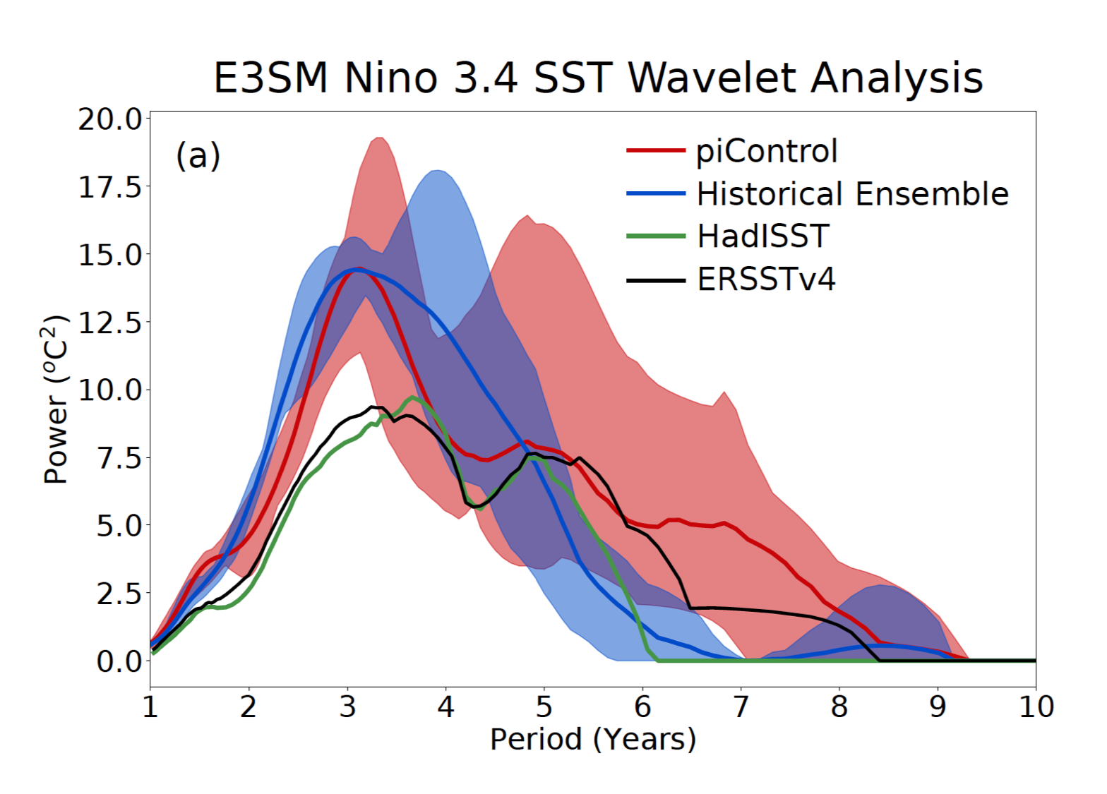
The long term variability of the El Nino Southern Oscillation (as simulated in the E3SM v1.0 control run and historical ensemble simulations) examined via wavelet analysis of Nino 3.4 Sea Surface Temperature (SST) (Golaz et al., JAMES 2019).
The E3SM version 1 simulation campaign continues into its second year, with the water-cycle-focused campaign winding down, biogeochemistry-oriented simulations continuing, and cryosphere-focused production simulations starting.
The water cycle campaign uses the E3SM version 1.0 configuration designed to study water and energy cycles in the atmosphere, ocean, sea ice, land and river components. E3SM version 1.0 also addresses water cycle science questions of interest to the U.S. Department of Energy, including issues relating to water availability, water cycle extremes, and interactions between the water cycle and the rest of the human-earth system on local to global scales. The v1.0 model also serves as a foundation for two additional simulation campaigns: a “biogeochemistry configuration” (version 1.1) with interactive nitrogen and phosphorous for studying interactions between biogeochemical cycles and other earth system components, and a “cryosphere configuration” (version 1.2) with added interactive ice-shelf cavities for assessing the impacts of ocean-ice shelf interactions on Antarctic Ice Sheet dynamics and the implications for sea level rise.
Water Cycle Campaign, E3SM v1.0
High-resolution (25 km atmosphere and land grid, 18 km at the equator to 6 km at the poles ocean and sea ice) coupled water cycle simulation has now successfully completed all 50 years. The companion 50 years of standard low-resolution run with exactly the same tuning are also complete.
Standard-resolution (100 km atmosphere/land) atmosphere-only (non-standard AMIP) water cycle simulations complement the already-completed more than 2000 years of Coupled Model Intercomparison Project Phase 6 Diagnosis, Evaluation, and Characterization of Klima (CMIP6 DECK) simulations. The additional almost 900 years of non-standard AMIP simulations include two three-member ensembles that were conducted to compute the time-varying total effective radiative forcing (ERF) between 1870 and 2014, as well as the aerosol-cloud forcing (ERFari+aci).
E3SM CMIP6 DECK data is avialable publicly at Earth System Grid Federation (ESGF), and details on water cycle campaign can be found on the Status of v1 Water Cycle Campaign page.
Biogeochemical Campaign, E3SM v1.1
The biogeochemical (BGC) simulations use the standard resolution configuration (100 km atmosphere/land, 30 km equator to 60 km midlatitudes to ~30 km poles ocean/sea-ice grid).
The experiments utilize two different land soil BGC approaches: the Convergent Tropic Cascade (CTC) and the Equilibrium Chemistry Approximation (ECA) configurations. (See the V1 BGC campaign page for more details.) The simulation campaign is designed to characterize the impacts of the structural uncertainties associated with the two approaches on the model’s coupled carbon-climate feedbacks.
The spin-up simulations for the CTC model configuration have been completed and production simulations for CTC runs have started, yielding a total of 1130 years of simulations completed by the end of 2018. In the first quarter of 2019, the ECA configuration spin-up was complete and an additional 1039 years of production simulations were performed (559 additional years of CTC simulations and 480 years of ECA simulations). Ten model runs are currently in progress (see the Table in Status of BGC Campaign for details). The model configurations (compsets) for the future simulations are close to being finalized and progress has been made on the CTC-CN spin-up.
Cryosphere Campaign, E3SM v1.2
The E3SM “v1.2” tag has been established recently, to mark the configuration of the model to be used in the Cryosphere v1 simulation campaign. The planned simulations include “CORE-forced” simulations, which have active ocean and sea ice components but atmospheric forcing and run-off from historical datasets since 1948 (Core-II Simulations), as well as fully-coupled (active atmosphere and land) configurations at both standard and medium resolution (i.e., 60-30 km and 30-10 km).
Standard-resolution (60 to 30 km), ocean-ice only simulations with ice shelf cavities:
- Four simulations began with different representations of Antarctic runoff (CORE-II cycles) to understand the Southern Ocean biases (fresh at surface, warm at depth) that contribute to unrealistically high ice shelf melt rates, and 320 out of 1200 years of simulations were completed.
Standard-resolution (60 to 30 km), pre-industrial coupled simulations with and without ice shelf cavities:
- A pair of coupled simulations with ice shelves, but with and without melt fluxes activated, have been run out 150 years. The simulation plan is to perform 200 years, the continuation is on hold until CORE-II simulations are completed and analyzed.
Medium-resolution (30 to 10 km), ocean-ice only simulations with ice shelf cavities:
- Both with and without melt flux simulations were started and ~5 and 10 years, respectively, have been completed thus far.
Read More
Find out more about the planned simulations on the “V1 Campaign” page.
Details and current status of the campaign are maintained on the “Status of v1 campaign” page, as well as specific science campaign pages:


