New capabilities of modeling multi-driver floods for E3SM
The Integrated Coastal Modeling (ICoM) project is an Energy Exascale Earth System Model (E3SM) ecosystem activity that aims to deliver a robust predictive understanding of coastal evolution, accounting for complex, multi-scale interactions among physical, environmental, and human systems. By leveraging an integrated approach that combines multiple modeling tools and simulations across scales, the ICoM team is examining both extreme events and long-term changes in human and natural coastal systems, with a focus on the U.S. mid-Atlantic region. ICoM is a multi-institutional endeavor supported by multiple U.S. Department of Energy (DOE) program areas, including Earth System Model Development (ESMD), Regional and Global Model Analysis (RGMA), and Multi-Sector Dynamics (MSD).
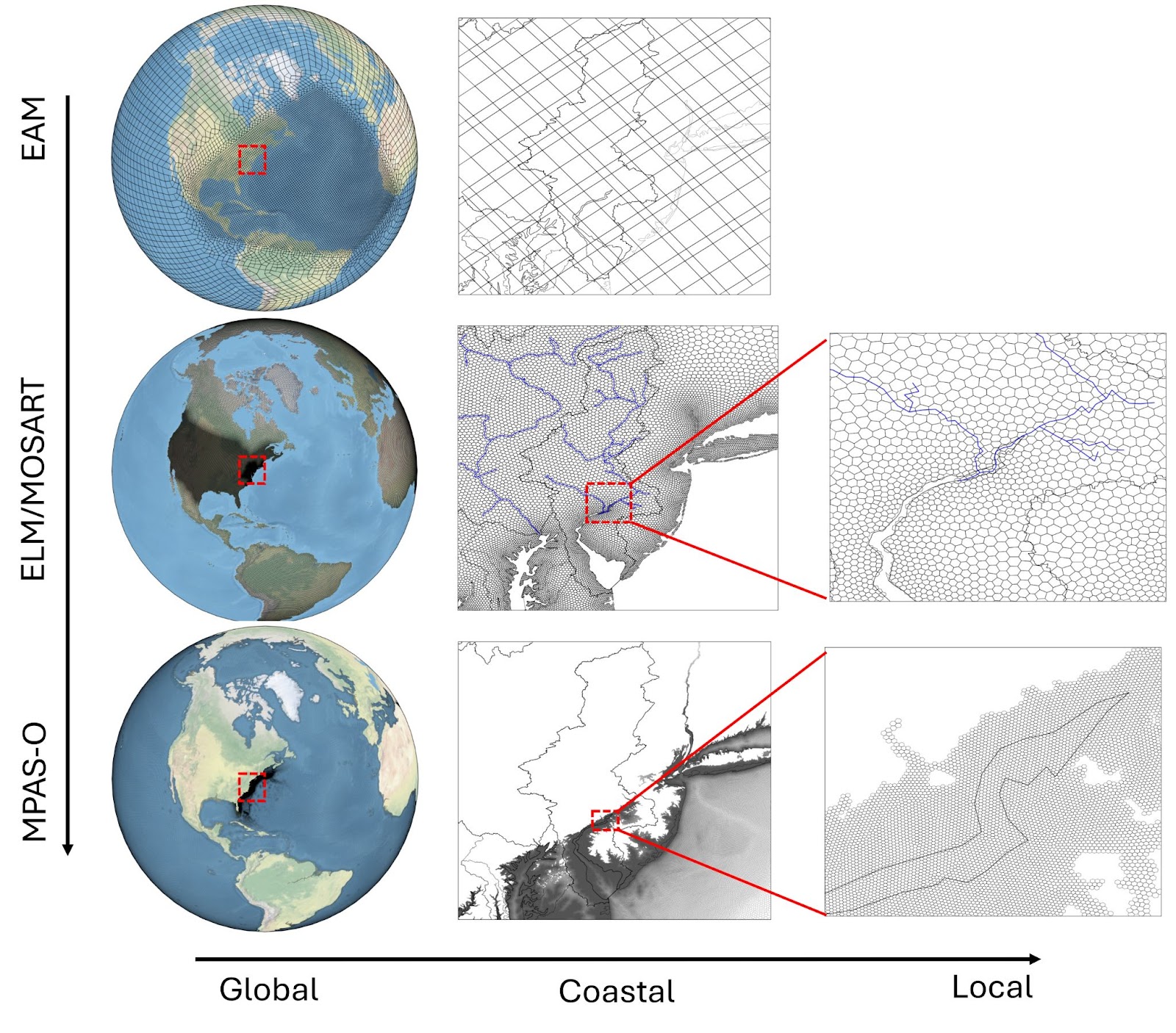
Within this collaborative effort, the ESMD team has focused on the development of a regionally refined, extreme storm- and weather-resolving, and coupled land-river-ocean model framework for E3SM (Fig. 1). As multi-driver, multi-scale hydrological processes, floods often involve multiple Earth system components (i.e. land, river, and ocean), especially in coastal regions. However, representations of flooding in current Earth system models (ESMs) focus mainly on riverine flooding. The ICoM project is working to bridge this gap by enhancing and extending E3SM capabilities to simulate pluvial (from rain), fluvial (from rivers), and coastal flooding at high resolution and with nonlinear interactions between ocean, river, and land physics explicitly represented. This holistic model framework allows comprehensive analysis of how riverine, ocean, and land processes contribute to flood events, including flooding associated with complex extreme events such as tropical cyclones (TCs). Furthermore, E3SM’s regionally refined framework allows us to resolve flood processes at high spatial resolution while retaining the large-scale context, which is helpful for disentangling the relative roles of different processes in driving changes in extreme events as climate change continues to alter hydrological and oceanic processes and interactions.
This summary highlights three key themes from recent ICoM-ESMD research and progress since our last report (Highlight from ICoM), each of which includes multiple studies. Collectively, these developments are improving our ability to predict multi-driver floods and our understanding of flood risks to coastal communities in the mid-Atlantic region and beyond.
1. Coupled River-Ocean Modeling and Compound Flooding
Simulating flooding where rivers meet the ocean is challenging because existing ESMs struggle to capture the complex interactions between river flows, ocean tides, and storm surges. To address the challenge of resolving compound flooding (CF), the ICoM-ESMD team developed a fully coupled E3SM configuration that integrates high-resolution, regionally refined meshes near the Mid-Atlantic coastline for the atmosphere (EAM, O[25km]), land/river (ELM/MOSART, O[5km]) and ocean (MPAS-O, O[250m]) components (Feng et al., 2024). Combined with multi-ensemble simulations and previous work to resolve tidal dynamics in E3SM (Brus et al., 2023), this novel configuration improves E3SM’s ability to predict extreme TC and CF events. In addition to simulations and analyses focusing on the mid-Atlantic region, the team used the new E3SM river-ocean coupling scheme to evaluate the combined exposure and hazard risks of CF along the coast of the contiguous United States (Feng et al., 2023a; Fig. 2). This comprehensive approach helps reveal CF risks that are not captured in purely statistical or hydrodynamics-based approaches.
2. Multi-driver Floods and Hydroclimate
Coastal regions face multiple threats associated with sea-level rise (SLR), which current ESMs often simplify or overlook. The ICoM-ESMD team has been using land-ocean coupling to study various aspects of multi-driver coastal hydroclimate, including the interaction between SLR and coastal groundwater systems. Xu et al. (2024a) developed the first land–ocean coupling scheme for E3SM; it includes lateral exchanges between seawater and groundwater, as well as vertical seawater infiltration resulting from oceanic inundation. Results from the coupled model under future climate warming and SLR scenarios reveal that SLR will not only intensify coastal flooding, but also raise groundwater levels in many coastal areas. These higher water tables will further exacerbate flood risks for coastal communities by increasing the likelihood of pluvial and fluvial flooding (Fig. 3). This research underscores the need for land-ocean coupled ESMs, as well as the coupling of surface and subsurface hydrological processes, to fully capture the impacts of SLR. Another exciting study under this theme is the development of a robust calibration procedure for E3SM to simultaneously constrain runoff generation (hydrological process) and river routing (hydraulic process) that contribute significantly to the magnitude and duration of pluvial and fluvial flooding (Xu et al., 2024b). Using the new calibration method, E3SM can reliably capture the variability of streamflow and floodplain water storage even in complex wetland systems.
3. Innovative Modeling Techniques
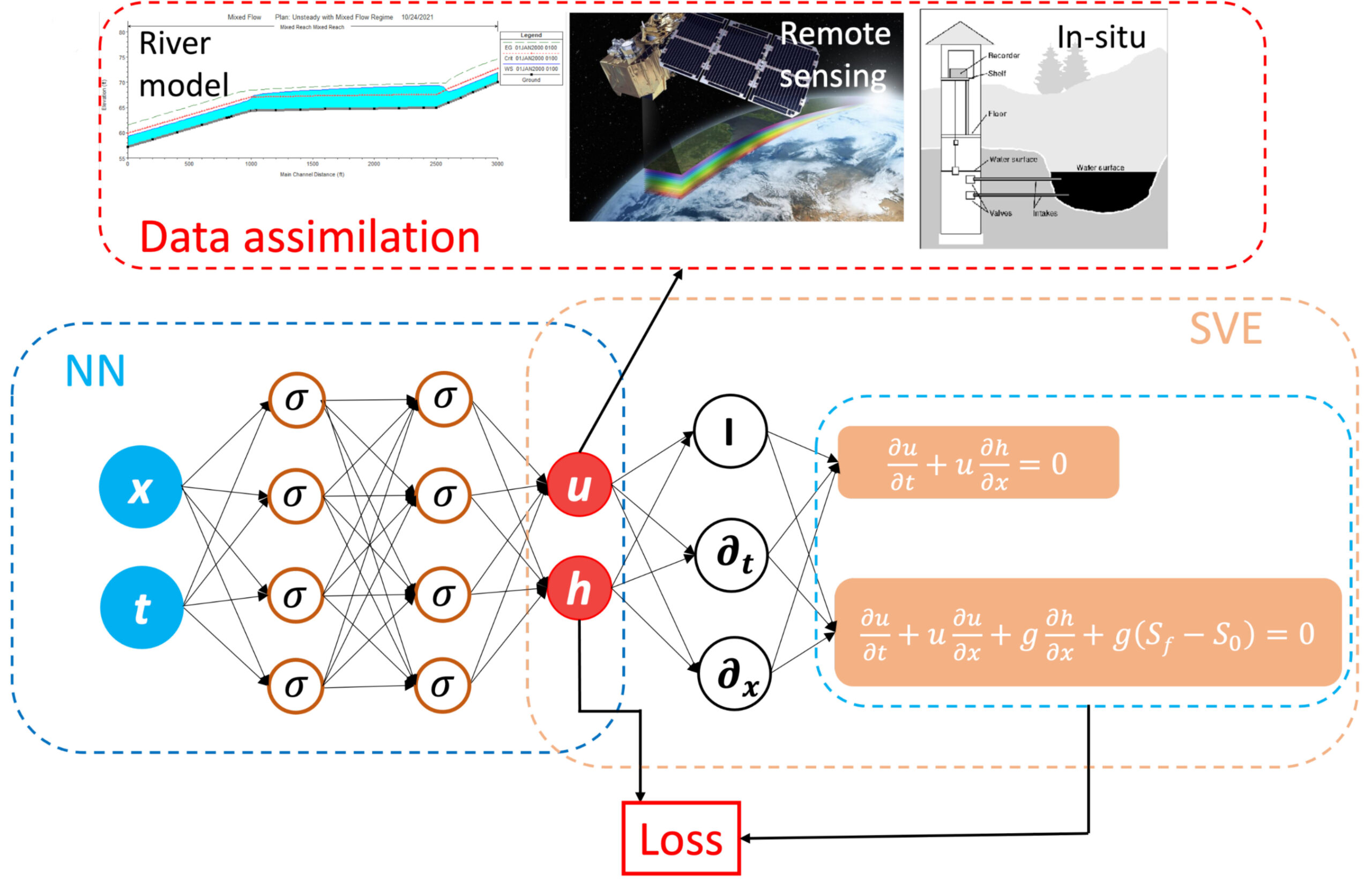
The application of innovative modeling techniques, such as physics-informed neural networks (PINNs) and topological relationship-based methods, represents a third major theme. As highlighted by Feng et al. (2023b) and Liao et al. (2023), these techniques are being used to downscale large-scale models and improve the resolution of critical processes, such as flow dynamics at the river-ocean interface and flow direction modeling in hydrological systems, respectively. Feng et al. (2023) offer a way to leverage machine learning to modernize coastal flood modeling in ESMs, allowing them to simulate fine-scale dynamics that are often overlooked but important for multi-driver floods (Fig. 4). Similarly, by incorporating novel stream burning and depression filling techniques into the variable-resolution river network generation tool (Liao et al., 2023; Fig. 1), the team is on track to deliver streamlined regionally refined E3SM configurations for the ICoM project, future phases of E3SM, and the broader research community.
References
- Feng, D., Tan, Z., Engwirda, D., Wolfe, J. D., Xu, D., Liao, C., et al. (2024). Simulation of compound flooding using river-ocean two-way coupled E3SM ensemble on variable-resolution meshes. Journal of Advances in Modeling Earth Systems, 16, e2023MS004054. https://doi.org/10.1029/2023MS004054
- Brus, S. R., Barton, K. N., Pal, N., Roberts, A. F., Engwirda, D., Petersen, M. R., et al. (2023). Scalable self attraction and loading calculations for unstructured ocean tide models. Ocean Modelling, 182, 102160. https://doi.org/10.1016/j.ocemod.2023.102160
- Feng, D., Tan, Z., Xu, D., & Leung, L. R. (2023a). Understanding the compound flood risk along the coast of the contiguous United States. Hydrology and Earth System Sciences, 27, 3911–3934. https://doi.org/10.5194/hess-27-3911-2023
- Xu, D., Bisht, G., Feng, D., Tan, Z., Li, L., Qiu, H., & Leung, L. R. (2024a). Impacts of sea-level rise on coastal groundwater table simulated by an Earth system model with a land-ocean coupling scheme. Earth’s Future, 12, e2024EF004479. https://doi.org/10.1029/2024EF004479
- Xu, D., Bisht, G., Tan, Z., Liao, C., Li, H.-Y., & Leung, L. R. (2024b). Disentangling the hydrological and hydraulic controls on streamflow variability in Energy Exascale Earth System Model (E3SM) V2. Geoscientific Model Development, 17, 1197–1215. https://doi.org/10.5194/gmd-17-1197-2024
- Feng, D., Tan, Z., & He, Q. Z. (2023b). Physics-informed neural networks of the Saint-Venant equations for downscaling a large-scale river model. Water Resources Research, 59, e2022WR033168. https://doi.org/10.1029/2022WR033168
- Liao, C., Zhou, T., Xu, D., Tan, Z., Bisht, G., Cooper, M. G., et al. (2023). Topological relationship-based flow direction modeling: Stream burning and depression filling. Journal of Advances in Modeling Earth Systems, 15, e2022MS003487. https://doi.org/10.1029/2022MS003487
Research Highlights
- Study Highlights New Advancements to Simulate Multiscale Coastal Processes
- Investigating Compound Flood Risk for the Coastal United States
- Downscaling a Large-Scale River Model Using Deep Learning
- New Universal Model For Multi-Scale Hydrologic Flow Routing
This article is a part of the E3SM “Floating Points” Newsletter, to read the full Newsletter check:


