

Highlight from ICoM
Integrated Coastal Modeling (ICoM):
New Tides, Storm-Surge and Inundation Capabilities for E3SM
The Integrated Coastal Modeling (ICoM) project is an E3SM ecosystem activity that aims to deliver a robust predictive understanding of coastal evolution, accounting for complex, multi-scale interactions among physical, environmental, and human systems. By leveraging an integrated approach that combines multiple modeling tools and simulations across scales the impact of both extreme events and long-term changes in human and natural coastal systems is appraised. ICoM is a multi-institutional endeavor supported by numerous U.S. Department of Energy (DOE) program areas, including the Earth System Model Development (ESMD), Regional and Global Model Analysis (RGMA) and Multi-Sector Dynamics (MSD) portfolios.
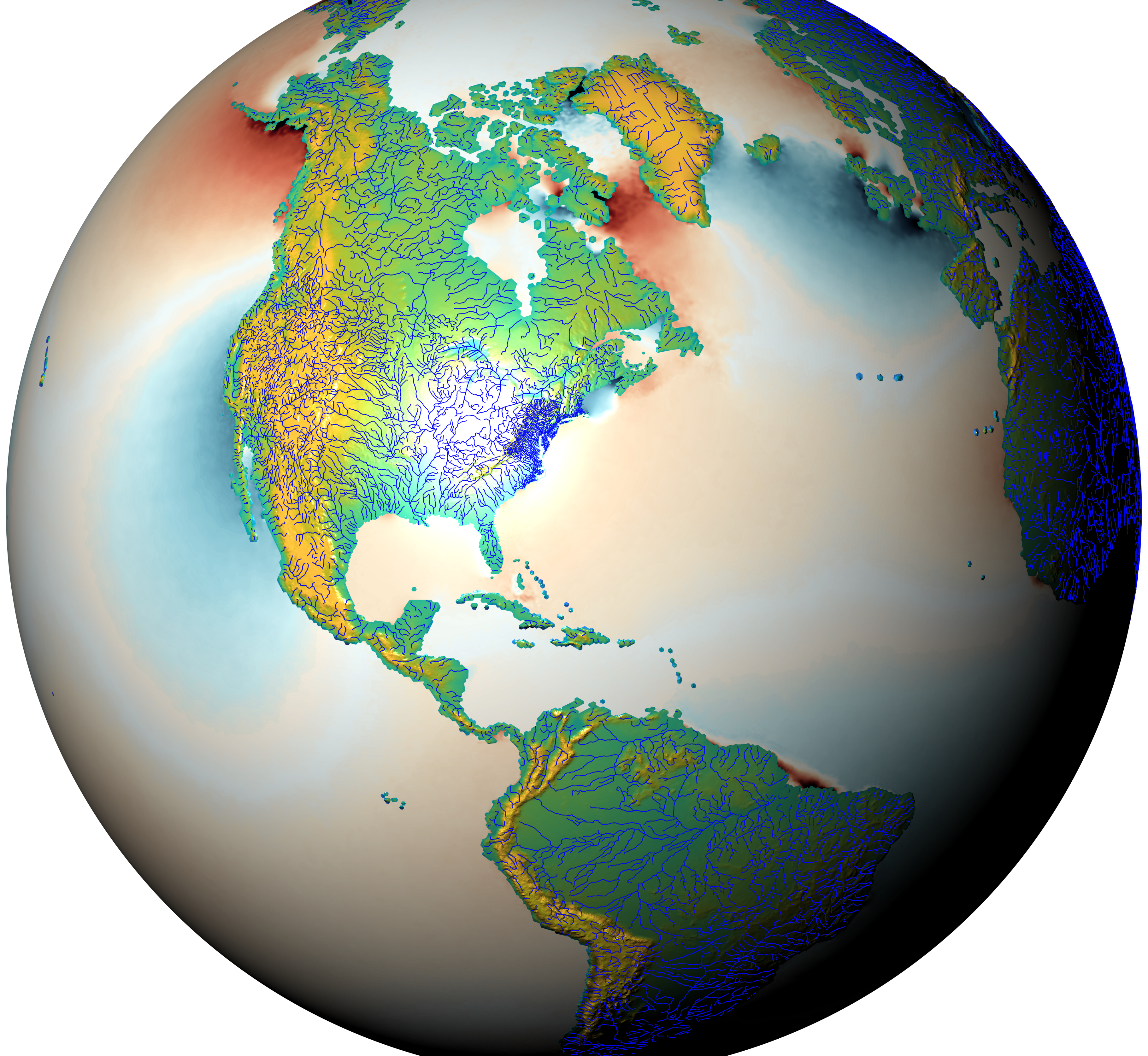
Figure 1. New tides, storm-surge, and inundation enabled E3SM, with MPAS-O, MOSART, and ELM running on a unified regionally-refined unstructured mesh.
In both its aims and methodologies, the ICoM project is a unique opportunity to enhance and extend E3SM capabilities to answer high-impact scientific questions relevant to US coastal communities and infrastructure. This work continues progress toward future E3SM configurations designed to simulate and assess impacts and changes to the coastal environment more broadly.
Within this collaborative effort, the ESMD team has focused on the development of a new extreme storm and weather impacts configuration for the ocean, land-surface and river components of the Energy Exascale Earth System Model (E3SM, Fig. 1). These new capabilities allow the impact of extreme events, including e.g. Tropical Cyclones, to be simulated at very high resolution over short time scales, with nonlinear feedbacks and interplays between ocean, river and land-surface physics explicitly represented. This dynamic, two-way coupling across model components enables the behavior of compounding events to be captured — allowing the team to analyze how rivers, oceans and land-surface processes contribute to storm-surge, flooding and inundation events, and to assess associated risks to coastal infrastructure. These new simulation capabilities have been enabled by incorporating various new functionality in E3SM, including:
Ocean Tides and Storm-Surge: Tidal dynamics are important contributions to extreme events and global processes, responsible for significant sea surface height fluctuations in nearshore regions as well as mixing processes in deep oceans and coastal estuaries. The action of the tidal cycle and storm-driven surge impacts can combine to generate substantial flooding and inundation in low lying coastal regions. Using a newly developed barotropic configuration of MPAS-Ocean, in which depth-averaged dynamics are solved using a simplified, single-layer approach, the team has implemented new tidal parameterizations, allowing MPAS-Ocean to accurately simulate tidal fluctuations throughout the global oceans and coastal zone, resolving tides and storm-surge effects down to sub-kilometer resolution [Barton et al, Brus et al]. The efficiency of the model has been enhanced using newly developed local time-stepping techniques that concentrate computational effort in highly resolved coastal regions of the global domain [Lilly et al].
Coupling, Inundation and Runoff Effects: Tightly integrating the dynamics of river, ocean and land-surface processes is critical to the representation of coastal flood risk, with the combined action of ocean storm surge, as well as pluvial (caused by intense precipitation) and fluvial (caused by overflowing rivers) flooding mechanisms responsible for compounding inundation events in the coastal zone. The team has developed new two-way coupling strategies to capture river-ocean backwater effects [Feng et al], land-river floodplain inundation processes [Xu et al], urban stormwater and runoff dynamics [Chegini et al], as well as optimized runoff parameterization techniques [Xu et al]. These new model capabilities enhance the capacity to simulate coupled flooding events at high resolution, and to assess flood risk in densely populated regions. Working with researchers from the Cross-Cutting, MSD and RGMA teams, these new E3SM capabilities have been used to model the coupled land-surface, river and ocean response to land-falling tropical storm events, providing detailed estimates of inundation throughout the coupled land-ocean-river system.
Unified Unstructured E3SM: Coupled exchanges between components in Earth System Models are often simplified by details of the underlying numerical approach. Ocean, land and river dynamics are generally represented using different computational grids and numerical techniques, and are not typically resolved at the fine spatial and temporal scales needed to capture coupled dynamics at the coast. Leveraging advanced unstructured meshing capabilities [Engwirda et al, Liao et al], the team has developed a new unified river, ocean and land-surface configuration for E3SM, in which all components are represented on a common, multi-scale unstructured mesh (Fig. 2), and employs compatible numerical formulations and coupling strategies. This unified E3SM configuration underpins the new high-resolution, two-way coupled science campaigns completed by the team.
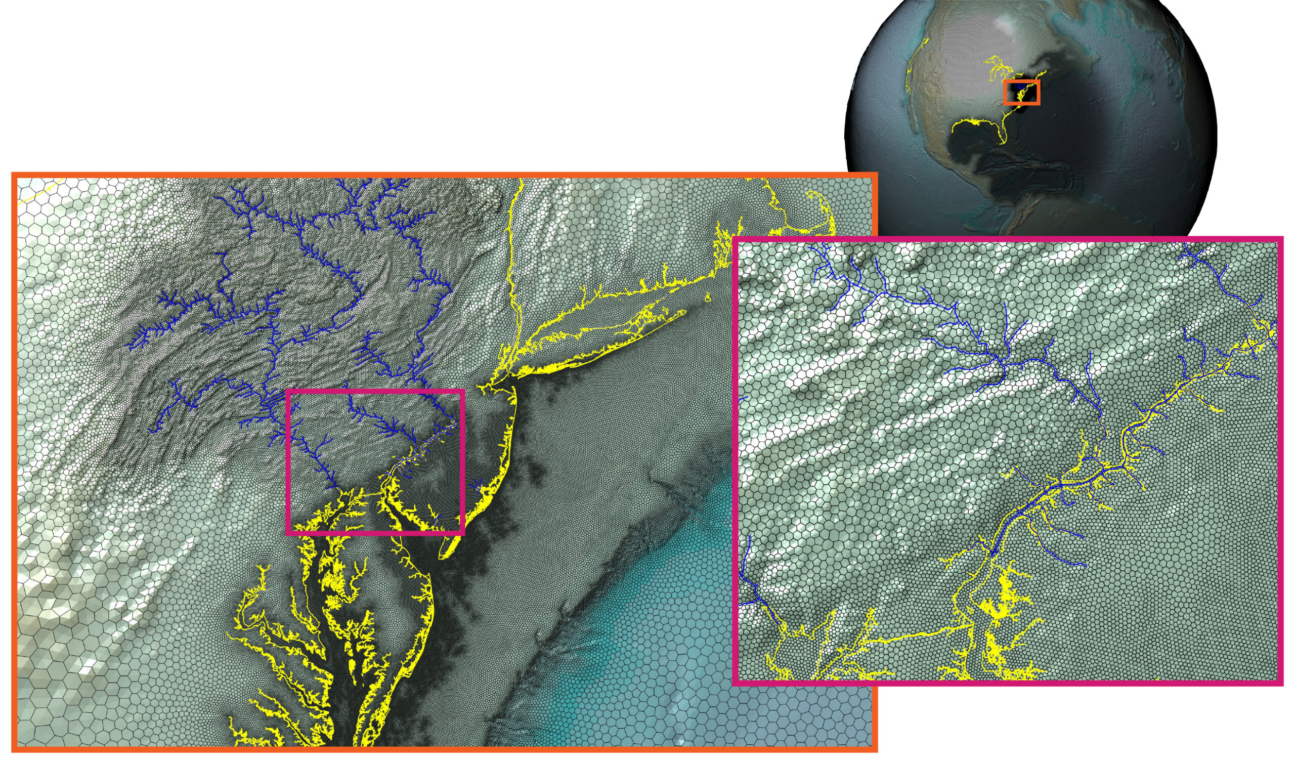
Figure 2. New unified E3SM computational grid, with ocean, land-surface and river components represented using consistent, regionally-refined meshes to facilitate two-way flux coupling.
Resources
Barton, K.N., Pal, N., Brus, S.R., Petersen, M.R., Arbic, B.K., Engwirda, D., Roberts, A.F., Westerink, J.J., Wirasaet, D. and Schindelegger, M., 2022. Global Barotropic Tide Modeling Using Inline Self‐Attraction and Loading in MPAS‐Ocean. Journal of Advances in Modeling Earth Systems, 14(11), p.e2022MS003207. DOI: 10.1029/2022MS003207
Brus, S.R., Barton, K.N., Pal, N., Roberts, A.F., Engwirda, D., Petersen, M.R., Arbic, B.K., Wirasaet, D., Westerink, J.J. and Schindelegger, M., 2023. Scalable self attraction and loading calculations for unstructured ocean tide models. Ocean Modelling, p.102160. DOI: 10.1016/j.ocemod.2023.102160
Lilly, J.R., Capodaglio, G., Petersen, M.R., Brus, S.R., Engwirda, D. and Higdon, R.L., 2023. Storm Surge Modeling as an Application of Local Time‐Stepping in MPAS‐Ocean. Journal of Advances in Modeling Earth Systems, 15(1), p.e2022MS003327. DOI: 10.1029/2022MS003327
Feng, D., Tan, Z., Engwirda, D., Liao, C., Xu, D., Bisht, G., Zhou, T., Li, H.-Y., and Leung, L. R.: Investigating coastal backwater effects and flooding in the coastal zone using a global river transport model on an unstructured mesh, Hydrol. Earth Syst. Sci., 26, 5473–5491. DOI: 10.5194/hess-26-5473-2022
Xu, D., Bisht, G., Zhou, T., Leung, L.R. and Pan, M., 2022. Development of Land‐River Two‐Way Hydrologic Coupling for Floodplain Inundation in the Energy Exascale Earth System Model. Journal of Advances in Modeling Earth Systems, 14(8), p.e2021MS002772. DOI:10.1029/2021MS002772
Xu, D., Bisht, G., Sargsyan, K., Liao, C. and Leung, L.R., 2022. Using a surrogate-assisted Bayesian framework to calibrate the runoff-generation scheme in the Energy Exascale Earth System Model (E3SM) v1. Geoscientific Model Development, 15(12), pp.5021-5043. DOI: 10.5194/gmd-15-5021-2022
Chegini, T. and Li, H.-Y.: An algorithm for deriving the topology of belowground urban stormwater networks, Hydrol. Earth Syst. Sci., 26, 4279–4300. DOI: 10.5194/hess-26-4279-2022
Liao, C., Zhou, T., Xu, D., Barnes, R., Bisht, G., Li, H.Y., Tan, Z., Tesfa, T., Duan, Z., Engwirda, D. and Leung, L.R., 2022. Advances in hexagon mesh-based flow direction modeling. Advances in Water Resources, 160, p.104099. 10.1016/j.advwatres.2021.104099
Liao, C., Zhou, T., Xu, D., Cooper, M.G., Engwirda, D., Li, H.Y. and Leung, L.R., 2023. Topological Relationship‐Based Flow Direction Modeling: Mesh‐Independent River Networks Representation. Journal of Advances in Modeling Earth Systems, 15(2), p.e2022MS003089. DOI:10.1029/2022MS003089
Engwirda, D.: JIGSAW-GEO (1.0): locally orthogonal staggered unstructured grid generation for general circulation modelling on the sphere, Geosci. Model Dev., 10, 2117–2140, DOI: 10.5194/gmd-10-2117-2017, 2017.
This article is a part of the E3SM “Floating Points” Newsletter, to read the full Newsletter check: