Understanding Changes in Cloud Simulations from E3SM Version 1 to Version 2

Clouds. Image by Billy Huynh, unsplash.
The Science
Given the importance of clouds in global radiative balance and hydrological cycle, continuously improving the representation of clouds has been a key focus for global climate model (GCM) development. For instance, major efforts have been devoted to reducing outstanding errors in clouds simulated in the Energy Exascale Earth System Model (E3SM) version 1 (E3SMv1) by the U.S. Department of Energy (DOE) during the development of its version 2 (E3SMv2).
In this study, scientists examined the model behavior change in clouds from E3SMv1 to v2. The focus was to document clouds simulated by the E3SMv2 and understand what caused the model behavior change in clouds relative to E3SMv1 using the Cloud Feedback Model Intercomparison Project (CFMIP) Observation Simulator Package (COSP) satellite simulators.
The Impact
The results from the sensitivity tests, through isolating the impact of changes in model parameters, provide more insights into future model development.

Figure 1. Annual mean CALIPSO-derived low-cloud fraction (left); the differences between E3SMv1 and observation (middle); and the differences between E3SMv2 and observation (right). The number after each panel name is the global annual mean of cloud fraction for observations or the global annual mean RMSE and correlation (in parentheses) for cloud fraction differences.
Summary
The scientists analyzed the last 30-year (1985–2014) data from the 165-year historical simulations using E3SMv1 and v2 and four sensitivity tests to isolate the impact of changes in model parameter choices in its turbulence, shallow convection, and cloud macrophysics parameterization (Cloud Layers Unified By Binormals, CLUBB); microphysical parameterization (MG2); and deep-convection scheme (ZM), as well as model physics changes in convective triggering.
The cloud evaluation presented in this study was performed using the community satellite simulator package – the Cloud Feedback Model Intercomparison Project (CFMIP) Observation Simulator Package (COSP) – to improve the consistency between model clouds and satellite observations. COSP contains several independent satellite simulators for better comparison of model clouds with satellite measurements collected by the International Satellite Cloud Climatology Project (ISCCP), the Moderate Resolution Imaging Spectroradiometer (MODIS), the Multi-angle Imaging SpectroRadiometer (MISR), Cloud-Aerosol Lidar and Infrared Pathfinder Satellite Observation (CALIPSO), and CloudSat. The use of satellite simulators not only made a fairer comparison between model clouds and satellite data but also allowed a more in-depth analysis of clouds. For example, clouds were assessed in terms of their optical properties and vertical location, which dictate their radiative effects.
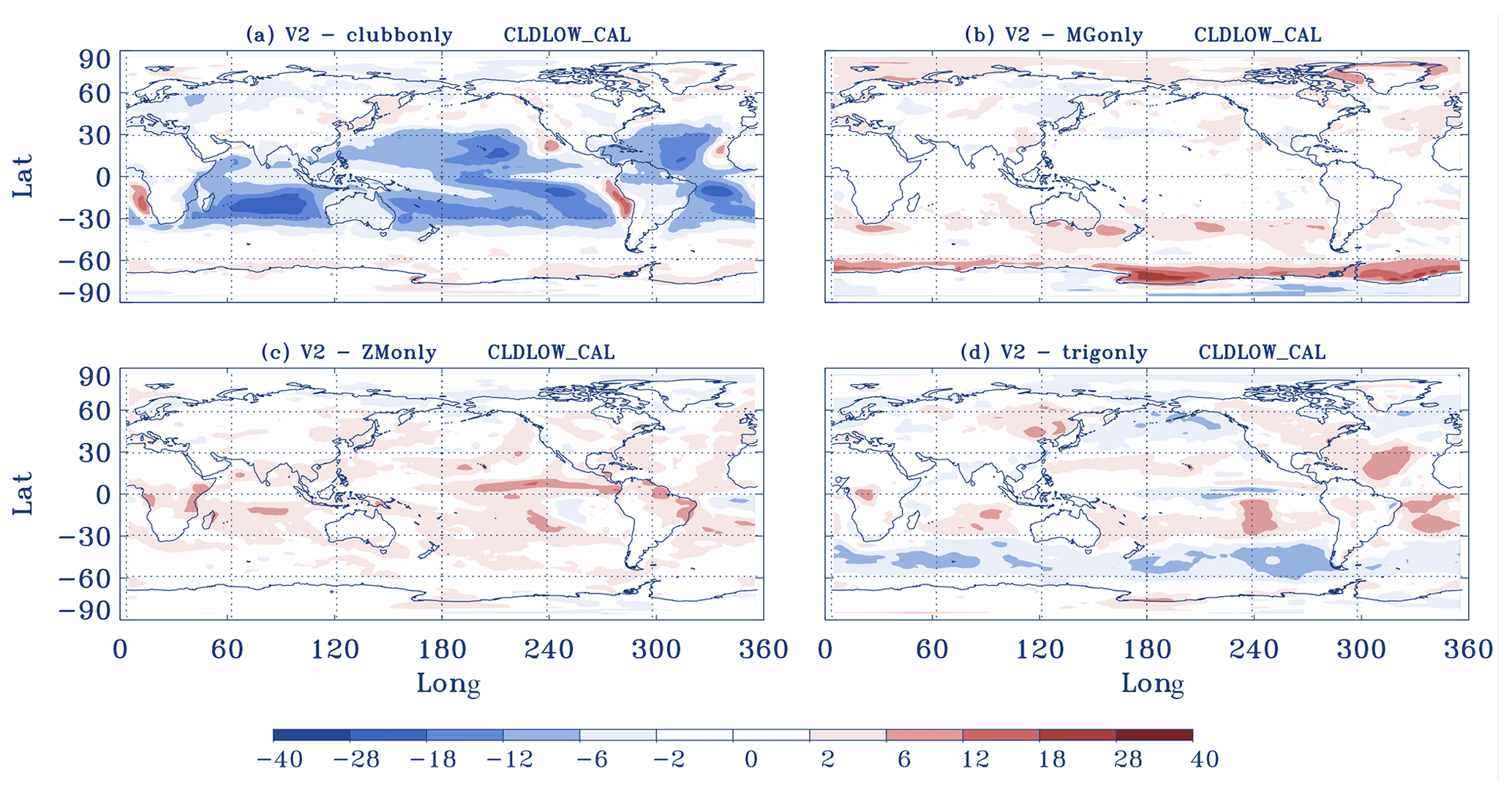
One robust improvement in E3SMv2 compared to its earlier version is the increase of stratocumulus clouds along the subtropical west coast of continents in both Hemispheres (Fig. 1). But we also found E3SMv2 shows a slightly larger negative bias in total low clouds than E3SMv1 in other regions in tropical and subtropical oceans (Fig. 2). From our sensitivity tests, we found these changes are mainly due to the re-tuning of CLUBB. The tuning made in MG2, ZM, and the use of the new trigger all help offset the reduction of clouds made by the CLUBB tuning over the tropical and midlatitude regions. But they play a bigger role in other types of clouds, such as the ZM tuning, which is mainly on optically intermediate and thick high clouds.

Figure 2. The difference in cloud fraction from the MODIS simulator (for cloud optical thickness Tau >1.3) between sensitivity tests and the default E3SMv2 run. (a) E3SMv2 with CLUBB-related parameters changed from v2 to v1, (b) E3SMv2 with MG2-related parameters changed from v2 to v1, (c) E3SMv2 with ZM-related parameters changed from v2 to v1, and (d) E3SMv2 with the dCAPE_ULL trigger turned off. All results are from 6-year AMIP-style climatology runs.
Publication
- Zhang, Yuying, Shaocheng Xie, Yi Qin, Wuyin Lin, Jean-Christophe Golaz, Xue Zheng, Po-Lun Ma, et al. 2024. “Understanding Changes In Cloud Simulations From E3Sm Version 1 To Version 2”. Geoscientific Model Development 17 (1). Copernicus GmbH: 169-189. doi:10.5194/gmd-17-169-2024.
Funding
- This work was supported by the Earth System Model Development program area of the Department of Energy, Office of Science, Biological and Environmental Research program.
Contact
- Shaocheng Xie, Lawrence Livermore National Laboratory
This article is a part of the E3SM “Floating Points” Newsletter, to read the full Newsletter check:


