

Nils Wedi on 1 km Resolution ECMWF ESM Simulation
ECMWF development towards 1 km global weather and climate simulations (https://doi.org/10.1029/2020MS002192).
Nils Wedi, Head of the Earth System Modelling (ESM) Section at the European Centre for Medium-Range Weather Forecasts (ECMWF) gave an inspiring keynote talk at the Earth System Model Development (ESMD) program area Principal Investigator (PI) and Energy Exascale Earth System Model (E3SM) Annual All-Hands Meeting in October 2020.
The ECMWF ESM Section addresses all aspects of scientific and computational performance relating to the ECMWF model and ensemble forecasting system. Nils Wedi develops strategies to secure the scalability of the model on future high-performance computing systems. He is the scientific coordinator of the European Union’s Horizon 2020 project ESCAPE-2 (Energy-efficient SCalable Algorithms for weather and climate Prediction at Exascale) which develops world-class, extreme-scale computing capabilities for European operational numerical weather and climate prediction systems.
In his keynote talk, Wedi presented “A baseline for global weather and climate simulations at 1 km resolution“, the ECMWF’s effort in pushing the frontier of simulating planet Earth with unprecedented resolution by testing its GPU-based model at 1-kilometer resolution for four simulated months on DOE’s Summit supercomputer. He summarized parallel efforts to improve performance and portability while handling increasing complexity for the different existing and emerging applications of ECMWF’s Integrated Forecasting System (IFS), also known as the “European Model”. Since the model is an operational weather forecasting model, the improvements are “non-disruptive”, evolutionary, and many options are under development in the model at the same time. Currently, the operational model is using a hydrostatic spectral transform (IFS-ST) dynamical core, but there is also a non-hydrostatic version (IFS-ST NH), as well as the newest core based on the finite volume method (IFS-FVM) which is expected to be in the operational model in 10 years. To enable the use of the different machine architectures and different dynamical cores, ECMWF developed a C++ library framework called ATLAS that takes care of translation of meshes, generating partitions and MPI parallel distribution (Fig. 1). Also, to accelerate the execution of the model, ECMWF is switching to single-precision floating-point calculations from the currently-used double-precision; the change will be operational next year.
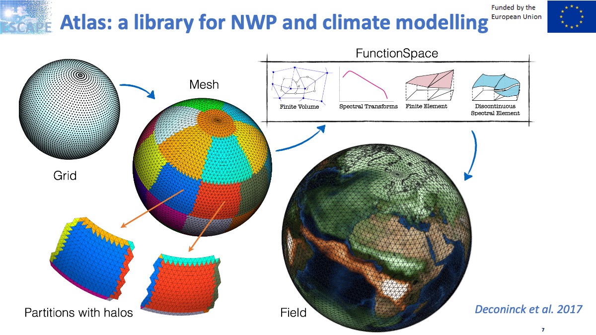
ECMWF developed a C++ library framework called ATLAS that takes care of translation of meshes, generating partitions and MPI parallel distribution (Wedi_presentation).
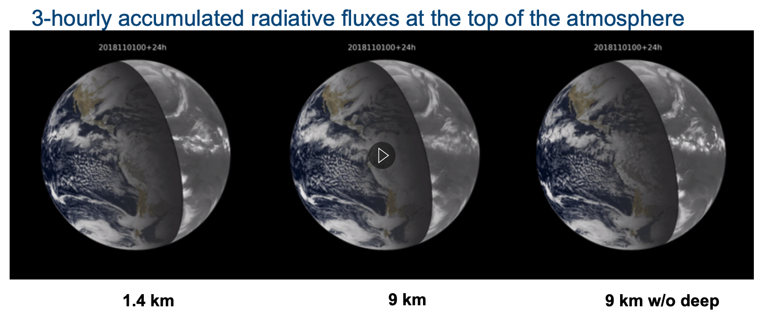
Wedi described recent efforts towards increasing realism with storm-scale-resolving simulations. In particular, he presented the impact of explicitly simulating deep convection on the atmospheric circulation and its variability as assessed by comparing the 1.4 km simulation to the equivalent well‐tested and calibrated global simulations at 9 km grid spacing with and without parametrized deep convection (Fig. 2). Wedi’s talk inspired significant audience interest and the Q&A discussion continued on the session’s Slack channel after his talk. This is not surprising since E3SM is heading in the same direction, i.e., pushing the higher resolution frontier in an exascale computing environment.
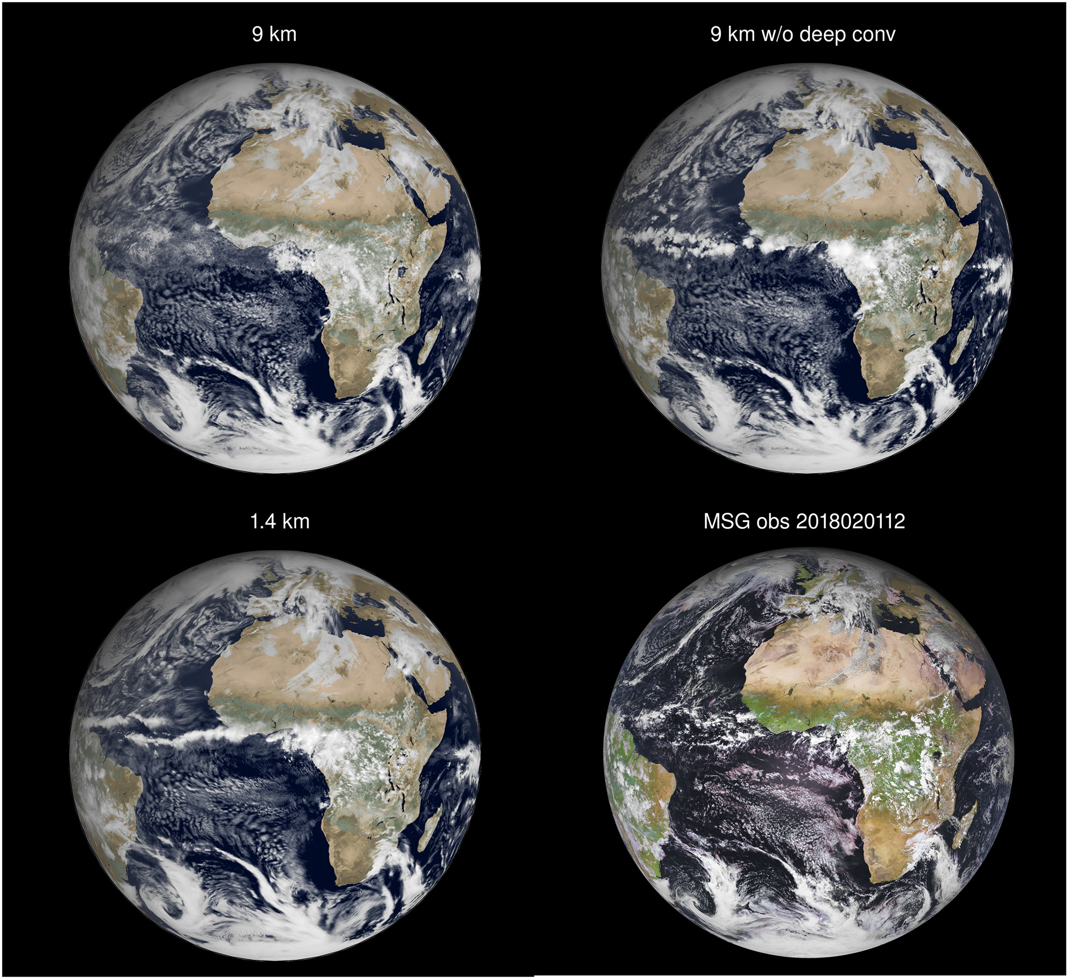
Simulated visible satellite images of the 9 km simulation with (top left) parametrized deep convection and (top right) without parameterized deep convection (meaning the deep convection was explicitly simulated) and (bottom left) of the 1.4 km simulation with explicitly simulated deep convection. The verifying visible Meteosat Second Generation satellite image is also shown (bottom right), at the same verifying time. Simulations are based on 3‐hourly accumulated shortwave radiation fluxes leading to a lack of sharpness (in the images only) compared to the instantaneous satellite image. Reference: http://doi.org//10.1029/2020MS002192.
References
- ESMD-E3SM keynote talk: “A baseline for global weather and climate simulations at 1 km resolution“
- Publication: N.P. Wedi, et al., 2020, “A Baseline for Global Weather and Climate Simulations at 1 km Resolution”, JAMES, https://doi.org/10.1029/2020MS002192