

How Floods Start and Their Recent Trends

A new floodplain inundation model more accurately represents floods and their causes.
Floodplain inundation simulations shed light on flood generation mechanisms and the increasing role of extreme rainfall in some basins.
The Science
Floods account for a significant and increasing number of reported natural hazards globally. As extreme precipitation is projected to increase in a warmer climate, there is an urgent need to enhance understanding and modeling of floods to improve flood prediction and inform infrastructure planning. Analyses of flood characteristics have focused on using streamflow data, but flood inundation area has more direct societal and ecological implications.
A team led by scientists at the U.S. Department of Energy’s Pacific Northwest National Laboratory calibrated and evaluated a newly-developed floodplain inundation model in the Energy Exascale Earth System Model (E3SM). Global simulations of flood inundation area for 1953 to 2004 revealed significant changes in flood generation mechanisms in some basins around the world. In the Amazon basin, for example, an increasing concentration of extreme rainfall events within the wet season has increased flooding in the recent decades by synchronizing the occurrence of extreme rainfall more often with saturated soil in the wet season.
The Impact
Despite the complex and highly dynamic nature of flood processes, this study demonstrated that a physically-based inundation model in E3SM can produce realistic simulations of floodplain inundation. Global simulations of flood inundation provided insights on the mechanisms for floods and their trends in major basins around the world.
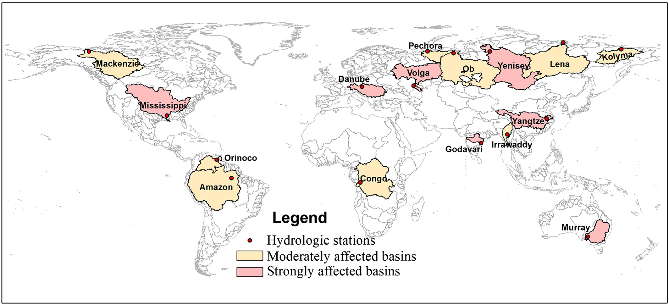
Figure 1. The 16 major basins across the world examined in this study overlaid with a classification map based on the level of anthropogenic streamflow regulation by dams (adapted from Nilsson et al., 2005).
Summary
In this study, scientists applied a newly-developed, physically-based inundation model coupled with a river routing model (Model for Scale Adaptive River Transport, MOSART) within the E3SM framework to investigate flood inundation dynamics. After calibration using observed streamflow and satellite-derived flood extent, the model was used to simulate global flood inundation from 1953 to 2004. The mean date and seasonality of annual maximum flood, defined based on flood extent, exhibit significant regional differences across 16 major basins.
Generally, soil moisture and monthly maximum daily rainfall are the dominant drivers of floods in tropical basins while monthly maximum daily snowmelt is the dominant driver in high latitude basins.
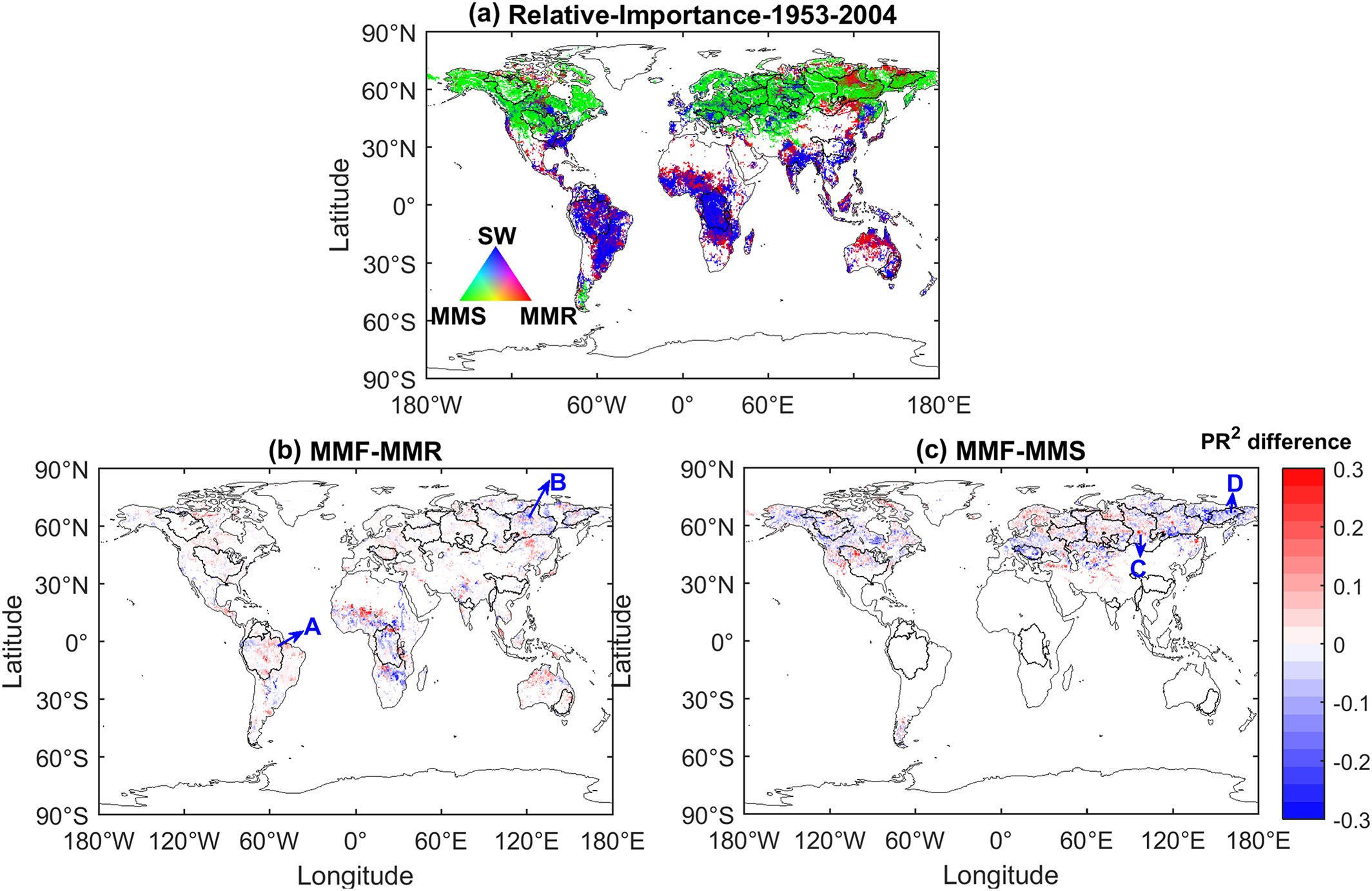
Figure 2. (a) Spatial distribution of the relative contributions of three predictors (MMR, MMS, and SW) to flooding at global grid scale. MMR is monthly maximum daily rainfall, MMS is monthly maximum daily snowmelt, and SW is monthly mean soil water content. (b) The changes of the relative contribution of MMR to the monthly maximum daily inundated area – referred to as the monthly maximum flood (MMF) – in the two periods (1953–1982 and 1975–2004). (c) The changes of the relative contribution of MMS to flooding in the two periods (1953–1982 and 1975–2004). Points A–D are four representative grid points used to explore the processes that may have contributed to changes in flood generation.
In the study, researchers performed analysis for two 30‐year periods from 1953 to 1982 and from 1975 to 2004, as 30 years is the minimum length of record often considered representative of a stable climate (Guttman, 1989; Jain & Lall, 2000). Comparing the 1953-1982 period to the 1975-2004 period, scientists detected significant changes in flood generation mechanisms in some basins such as the Amazon, Lena, Yenisey, and Kolyma. Analysis of the rainfall seasonality and water balance at grid scale reveals that during the later period, the occurrence of extreme rainfall is concentrated more in the wet season in the Amazon, which increases the co-occurrence of extreme rainfall and wet soil to produce flooding. In the Lena basin, fewer extreme rainfall events found in the later period reduced the contribution of monthly maximum rainfall to floods. For the snowmelt-dominated Yenisey basin, soil moisture has significantly increased in the second period so snowmelt contributed more directly to flood generation. Lastly, with increased soil moisture approaching the maximum soil water storage capacity in the Kolyma basin, floods can occur even without large monthly maximum snowmelt, so large snowmelt events play a less important role in the later period. In addition, the frequency of large monthly maximum snowmelt declined in the later period, further reducing its contribution to floods.
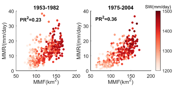
Figure 3. Monthly maximum daily rainfall (MMR) explains a larger fraction of variance in monthly maximum flood (MMF) in the 1975-2004 period (right) than the 1953-1982 period (left). In the later period, soil wetness (SW) is high when MMR is also high.
As shown in Figure 2, scientists focused on three factors that contribute to flooding: monthly maximum daily rainfall (MMR), monthly maximum daily snowmelt (MMS), and monthly mean soil water content(SW). The researchers determined the flood generation mechanisms at each grid by calculating the relative importance of these three factors at the monthly scale based on the coefficient of partial determination (i.e., PR2, significance level α = 0.05) between the three predictors and floods to quantify the additional contribution of each predictor after the other predictors are controlled.
This study demonstrates the usefulness of the floodplain inundation model in E3SM for understanding floods and predicting their future changes.
Publication
- Mao, Y., T. Zhou, L.R. Leung, T.K. Tesfa, H.-Y. Li, K. Wang, Z. Tan, and A. Getirana. 2019. “Flood Inundation Generation Mechanisms and Their Changes from 1953 to 2004 in Global Major River Basins.” J. Geophys. Res., doi:10.1029/2019JD031381.
Funding
- The U.S. Department of Energy Office of Science, Biological and Environmental Research supported this research as part of the Earth System Modeling Program Area through the Energy Exascale Earth System Model (E3SM) project. L.R. Leung was also supported by the Terrestrial Ecosystem Science Program through the Next Generation Ecosystem Experiment (NGEE) Tropics project.
Contact
- L. Ruby Leung, Pacific Northwest National Laboratory