

Footprint of Large-scale Climate Variabilities on Regional Weather Systems

Clouds approaching the mountains near Seattle, Washington. Image by Chandler Cruttenden, Unsplash.
For the first time, a novel weather system clustering scheme, using a deep learning model, connects the influence of ENSO and MJO with regional weather and hydrological conditions
The Science
Weather system clustering refers to the identification and categorization of weather systems into a limited number of distinct patterns/clusters. These patterns/clusters provide a high-level summary of regional weather conditions, and connect them to both large-scale climate variabilities and regional hydrological processes. Using regional meteorological data from an atmosphere reanalysis product, scientists identified twelve unique winter weather systems in the Puget Sound area, featuring differing precipitation and temperature responses to large-scale climate variabilities. By connecting the large-scale drivers to regional hydrologic conditions, the weather system clustering highlights two types of flood-inducing weather in the region: one causes excess precipitation, while the other causes both enhanced precipitation and intense snowmelt under warm temperatures.
The Impact
Precipitation and temperature are important drivers of the land hydrologic process in the snow-dominated U.S. Puget Sound region. Although they are known to be modulated by some well-known modes of large-scale climate variability, such as El Nino and Southern Oscillation (ENSO) and Madden-Julian-Oscillation (MJO), existing weather system classification schemes fail to reflect such modulation on weather timescales. The new weather system clustering scheme developed in this study successfully connects regional precipitation and temperature to ENSO/MJO and allows a process-level understanding of these modulations. The findings suggest a new potential of understanding regional weather in the context of both large-scale climate variabilities and regional hydrological processes. This study also demonstrates that new insights in regional hydroclimate can be achieved with deep learning.
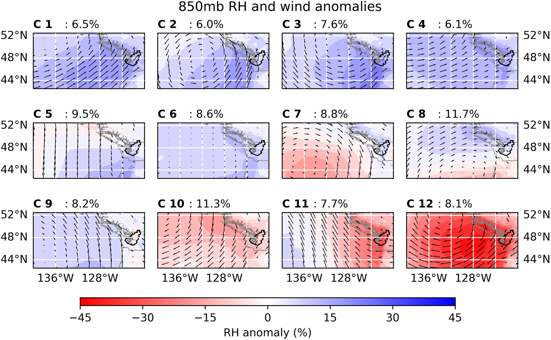
Figure 1. Weather system clusters in the U.S. Pacific Northwest Puget Sound region. A deep learning model identifies twelve clusters (labeled C 1 – C 12) with distinct relative humidity (RH), temperature, and wind conditions. In these panels, black polygons indicate the Puget Sound basin, shadows indicate the RH anomaly level, and quivers indicate the wind level. Numbers indicate their frequency during the cold season (October – March). Precipitation induced by these weather systems gradually decreases from cluster 1 (C1) to 12 (C12).
Summary
Researchers analyzed daily atmospheric conditions surrounding the Puget Sound area from a reanalysis product during the cold season (October – March) of 1981-2020 using a clustering model with a deep learning encoder. Tuned for optimal concurrent precipitation and temperature predictive skills, the clustering model identifies twelve unique regional weather systems, each featuring differing atmospheric temperature (as opposed to surface temperature), humidity, and wind patterns (Fig 1). Some of these systems resemble the well-recognized meteorological systems in this region, such as atmospheric rivers (e.g., C 1) and the Aleutian low pressure system (e.g., C 2).
These weather systems can correctly reflect the regional modulations of ENSO and MJO: weather systems associated with high precipitation show similar responses to ENSO/MJO phases as the patterns of precipitation itself. This suggests that these weather systems can be used to understand the physical mechanism of ENSO/MJO modulation on precipitation in this region. Meanwhile, they also reflect the unique precipitation and temperature combination in the Puget Sound region, highlighting two types of flood-inducing weather: one causes intense precipitation, and the other causes both high precipitation and warm temperatures, which brings notable snowmelt contribution to flood. The weather systems identified in this study can be used to evaluate the global/regional climate model performance and provide a foundation for improved high-level summary and analysis of the regional weather conditions.
Publication
- Chen, X., Leung, L. R. & N. Sun. “Weather Systems Connecting Modes of Climate Variability to Regional Hydroclimate Extremes”. Geophysical Research Letters, 50, e2023GL105530 (2023). [DOI: 10.1029/2023GL105530]
Funding
- This research is supported by the Department of Energy, Office of Science, Biological and Environmental Research program as part of the Earth System Model Development, Regional and Global Modeling and Analysis, and MultiSector Dynamics program areas.
Contact
- Ning Sun, Pacific Northwest National Laboratory, (ning.sun@pnnl.gov)
This article is a part of the E3SM “Floating Points” Newsletter, to read the full Newsletter check: