Evaluation of Ocean and Sea Ice Climate of E3SM
Detailed analysis of E3SM simulations show good agreement with observations
The first publication of E3SM ocean and sea ice simulations demonstrates its ability to produce realistic currents, heat transport, and sea ice extent using new unstructured-mesh climate model components.

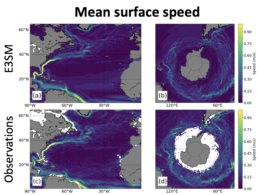
E3SM high-resolution simulation for ocean surface currents (m/s) in the Atlantic Ocean (left) and Southern Ocean (right). Observations in lower panels are from the surface drifter climatology of Laurindo et al. (2017). Image from Petersen et al. 2019, Fig. 9.
The Science
By using regional refinement of the horizontal grid for all components of the model, E3SM allows researchers to place high resolution where it is most beneficial for the topic at hand, be it regional climate studies, coastal impacts, or melting under ice shelves. In this paper, scientists present standard “CORE-forced” simulations, which have active ocean and sea ice components, but atmospheric forcing and run-off from historical datasets since 1948.
The Impact
Validation studies are an essential prerequisite for new climate models such as E3SM to be accepted by the scientific community. This publication and the parallel study by Golaz et al. (see Overview Paper on Coupled Model) follow standard protocols for model initialization, forcing, and analysis so that results may be directly compared against observations and other climate models. Such model documentation serves as the foundation for future E3SM studies that delve into more specific scientific questions. Both publications are part of the AGU Journals’ E3SM Special Issue. Future applications employing enhanced regional refinement will provide novel directions of scientific inquiry. Many research topics will greatly benefit from the unique multi-physics and multi-resolution capabilities of E3SM, including: coupled ocean-land-ice interactions; coastal studies of local sea level rise impacts; ocean-atmospheric feedbacks; and high-latitude dynamics.

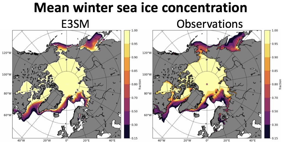
Sea ice concentration (normalized fraction) versus observations (SSM/I NASATeam algorithm; Calavieri et al., 1996), where both are compared over January to March for the period 1979-2009, for the lower resolution E3SM simulation. Image from Petersen et al. 2019, Fig. 14.
Summary
The Energy Exascale Earth System Model (E3SM) is a new coupled Earth system model sponsored by the US Department of Energy. In this paper, the authors present E3SM global simulations using active ocean and sea ice that are driven by the CORE-II inter-annual atmospheric forcing data set. The E3SM ocean and sea-ice components are MPAS-Ocean and MPAS-Seaice, which use the Model for Prediction Across Scales (MPAS) framework and run on unstructured horizontal meshes. For this study, grid cells vary from 30 to 60 km for the low resolution mesh and 6 to 18 km at high resolution. The vertical grid is a structured z-star coordinate and uses 60 and 80 layers for low and high resolution, respectively. The lower resolution simulation was run for five CORE cycles (310 years) with little drift in sea surface temperature or heat content. The meridional heat transport is within observational range, while the meridional overturning circulation at 26.5oN is low compared to observations. The largest temperature biases occur in the Labrador Sea and western boundary currents, and the mixed layer is deeper than observations at northern high latitudes in the winter months. In the Antarctic, maximum mixed layer depths (MLD) compare well with observations, but the spatial MLD pattern is shifted relative to observations. Sea-ice extent, volume and concentration agree well with observations. At high resolution, the sea surface height compares well with satellite observations in mean and variability.
Publication
et al., (2019), An evaluation of the ocean and sea ice climate of E3SM using MPAS and interannual CORE‐II forcing, J. Adv. Model. Earth Syst., 11, https://doi.org/10.1029/2018MS001373
Contact: Mark Petersen, Los Alamos National Laboratory
Funding: The Department of Energy, Office of Science, Office of Biological and Environmental Research (BER) supported this research.


