Antarctic Ice Sheet Modeling Highlighted on BER Website
The following is based on and excerpted from the June 2019 cover story on the DOE BER website by Shannon Brescher Shea titled Simulating Ice at the Bottom of the World: Modeling the Antarctic Ice Sheets
In 2007, the Intergovernmental Panel on Climate Change published its regularly issued report—the world’s biggest and most comprehensive report on climate change. That report noted that then-current computer models of ice sheets weren’t good enough to accurately predict how those sheets would react to climate change and influence sea level rise, a critical gap in understanding the climate system.
The Department of Energy’s (DOE) Office of Science responded to that need by supporting researchers to develop better models that can provide insight into how and when changing ice sheets will affect sea level rise and other parts of the climate. In 2009, the Office of Science funded six projects under the Ice Sheet Initiative for Climate Extremes (ISICLEs). It continued that funding through the Predicting Ice Sheet and Climate Evolution at Extreme Scales (PISCEES) project in 2012 and the Probabilistic Sea-Level Projections from Ice Sheet and Earth System Models project in 2017.
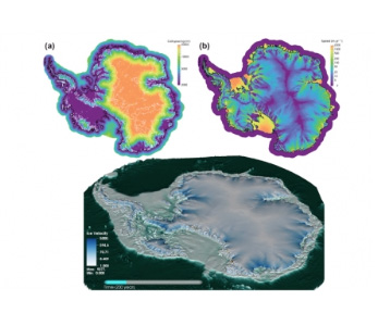
Screenshots from the MALI and BISICLES computer models simulating what the Antarctic ice sheet would look like and how fast ice would move 200 years after the ice sheet’s floating ice shelves have disintegrated.
Image Credit: MALI model, developed by DOE’s Los Alamos and Sandia National Laboratories and BISICLES model, developed by DOE’s Lawrence Berkeley National Laboratory, University of Bristol, and University of Swansea.
Work supported by DOE via the Scientific Discovery through Advanced Computing (SciDAC) program over the past nine years resulted in two new ice sheet models that tackle many of these challenges: MPAS-Albany Land Ice (MALI) and Berkeley Ice Sheet Initiative for Climate Extremes (BISICLES). Having more than one model allows DOE scientists to compare and contrast different assumptions and sources of uncertainty.
Scientists have completed fully operational models and are testing how model ice sheets disintegrate as well as how each model compares to the other. Results have been good so far. For example, at a test of one-kilometer (0.6-mile) resolution, MALI simulated the thickness of certain ice accurately down to the meter. Other tests have shown that MALI is correctly mimicking how the grounding line moves under different circumstances. The BISICLES model is slightly simpler than MALI, and allows scientists to run it for larger regions and over longer periods of time using the same computing resources. BISICLES, like MALI, places resolution only where it’s needed, however, instead of changing the shape of the modeling grid like MALI, BISICLES splits each grid cell into smaller and smaller ones. As the model evolves, it can automatically shift and adapt that resolution to place it where it is most needed.
To take ice sheet models to the next level, the teams are working to fully integrate MALI and BISICLES into DOE’s E3SM model.
Read the full story, “Simulating Ice at the Bottom of the World: Modeling the Antarctic Ice Sheets“, on the DOE BER website.
Additional References
- April 2019 E3SM news story – Antarctic Ocean Warming Affects Sea Level Rise
- October 2018 E3SM news story – Antarctic Ice Sheet Simulations