

Adding Ice Shelves Improves the Accuracy of Global Tidal Models
By including ice shelf cavities, errors in modeled Southern Ocean tides were reduced by up to 50% relative to satellite observations.
The Science
The coastlines and water depth of oceans influence global tides, just as the shape and thickness of a violin’s wood determines its musical vibrations. Ocean simulations with realistic continents and bottom depth can model tides by including external forces imposed by the sun and the moon. Ice shelves are floating decks of ice that protrude from the Antarctic continent. Below these ice shelves are large ocean cavities, which influence tides in the Southern Ocean and throughout the globe. This work adds the geometry of ice shelf cavities to global ocean simulations. The researchers compared the model results to the sea surface height observed by satellites and tide gauges around Antarctica. Adding ice shelf cavities substantially improves the model accuracy.
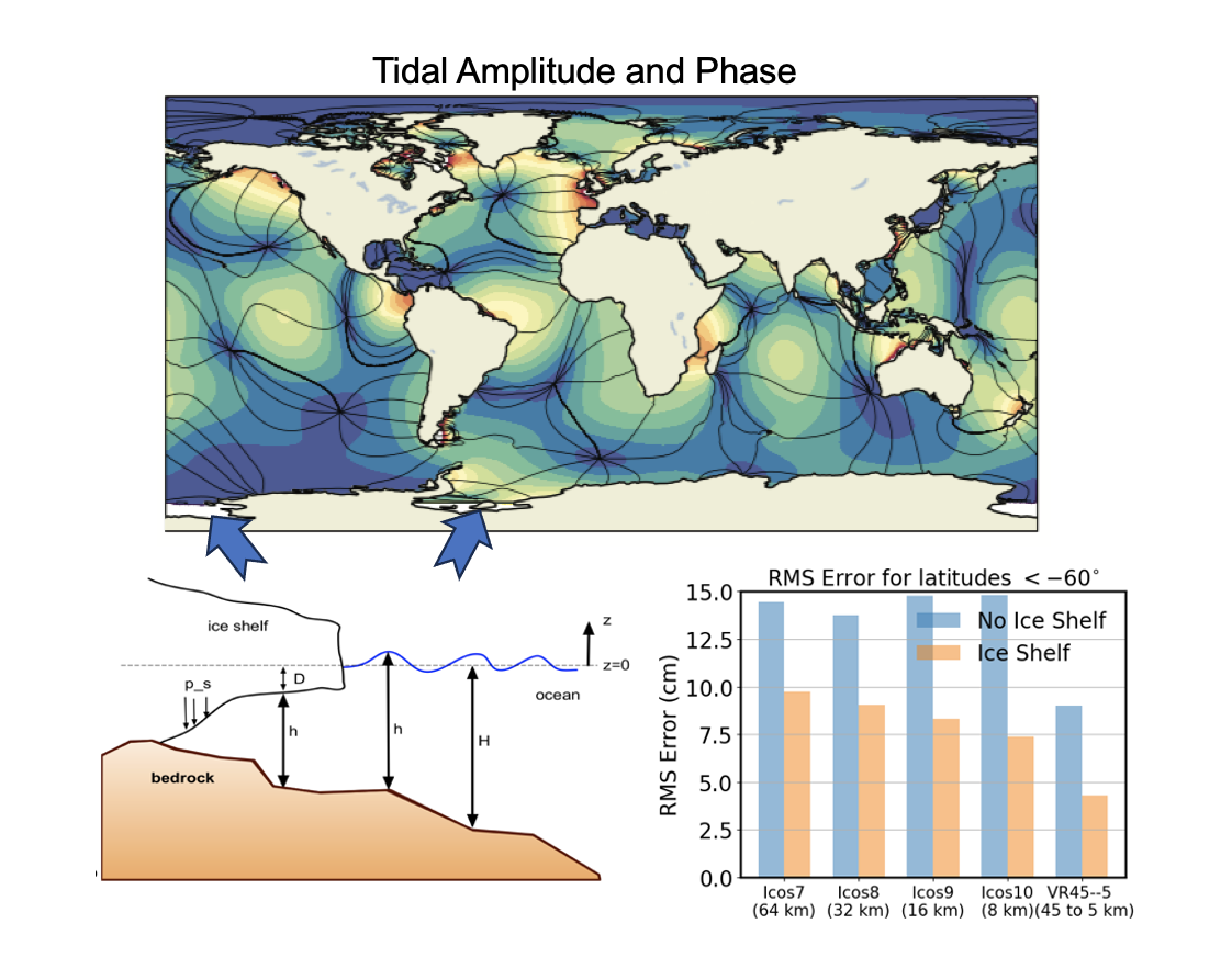
Figure 1. Global simulations of tides are much closer to observations when ice shelf cavities are included. Tidal amplitude (colors) and phase (lines) from MPAS-Ocean (top), with a diagram of an ice shelf cross-section (bottom left) and the error in simulations compared to observations for different resolutions (bottom right). (Image by Nairita Pal and Mark Petersen | Los Alamos National Laboratory)
The Impact
Global simulations with and without ice shelves were compared at global uniform resolutions of 64 to 8 km grid cells, with a single variable resolution mesh of 45 to 5 km grid cells. Researchers analyzed the results for the amplitude and phase of the five largest tidal constituents (Fig. 1). Adding ice shelves reduced errors compared to satellite observations by up to 50% near Antarctica and 5 – 10% globally. The variable-resolution mesh produced significantly lower errors than the uniform-resolution simulations. Tidal modeling is important for coastal inundation studies of future earth system, so validation against observations and improved accuracy is a critical first step.
Summary
Oceanic tides are seldom represented in Earth system models due to the need for a high horizontal resolution to accurately represent the associated waves near coasts. Recently, the ability to model tides was added to the Model for Prediction Across Scales-Ocean (MPAS-Ocean), the ocean component within the Energy Exascale Earth System Model developed by the Department of Energy. MPAS-Ocean circumvents the resolution limits by using variable-resolution global meshes, allowing fine grid cells to be added to critical regions such as coastlines.
This work adds the geometry of ice shelf cavities to these global ocean simulations. Tidal constituents calculated using MPAS-Ocean were evaluated against long-term satellite observations of sea surface height. The addition of ice shelves substantially lowers the error in the Southern Ocean and even improves the accuracy of forecasted tides far from the ice shelves. These modifications to MPAS-Ocean will enable further studies with potential future Antarctic ice shelf geometries, sea ice distributions, and sea level change to investigate the impact of earth system change on coastal communities.
Publication
- Pal, Nairita, Kristin N. Barton, Mark R. Petersen, Steven R. Brus, Darren Engwirda, Brian K. Arbic, Andrew F. Roberts, Joannes J. Westerink, and Damrongsak Wirasaet. 2023. “Barotropic Tides in MPAS-Ocean (E3SM V2): Impact of Ice Shelf Cavities”. Geoscientific Model Development 16 (4). Copernicus GmbH: 1297-1314. doi:10.5194/gmd-16-1297-2023.
Funding
- This work was supported by the Earth System Model Development program area of the Department of Energy, Office of Science, Biological and Environmental Research program.
Contact
- Darren Engwirda, Los Alamos National Laboratory