

A Roadmap for Adding Lateral Water Transport to the E3SM Land Model
Introduction
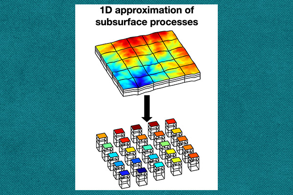
Figure 1. The E3SM Land Model (ELM) currently assumes that grid cells are flat and laterally disconnected. The short-term goal is to represent lateral water movement within individual ELM grid cells, while the long-term goal is to represent water transport across grid-cell boundaries
Most Earth System Models (ESMs), including E3SM version 3.0 (Golaz et al., 2026), represent water transport within soils as a one-dimensional vertical process. Although this formulation is computationally efficient, it does not explicitly represent the topography-driven lateral subsurface water flow from ridges to valleys. Lateral subsurface water redistribution may represent an important source of land memory for seasonal-to-decadal prediction by generating seasonal-to-multiyear persistence in soil moisture and associated evapotranspiration anomalies (Martínez-de la Torre and Miguez-Macho, 2019). Maxwell and Condon (2016) showed that including lateral water transport can strongly affect surface energy partitioning in regions with shallow water tables.
Representing lateral transport becomes increasingly important as E3SM moves toward higher spatial resolution. Global and regional models with kilometer-scale or finer grids require more realistic representations of surface and subsurface hydrology. Recent three-dimensional groundwater–land-surface simulations demonstrate the potential to represent variably saturated flow at large scales (Kollet et al., 2026), but their computational requirements, data volumes, and implementation complexity remain significant challenges for global Earth system modeling (Zhang et al., 2024). E3SM therefore needs a staged strategy that improves physical realism while retaining computational scalability (Fig. 1).
Short-Term Plan: Lateral Transport Within an ELM Grid Cell
The short-term development plan will represent lateral water movement within each E3SM Land Model (ELM) grid cell. The team will leverage the existing topo-unit subgrid structure within ELM (Tesfa et al., 2024) to include a hillslope representation that captures the dominant topographic controls on water redistribution. The use of representative hillslopes has previously been successfully implemented in other land surface models, including the Community Land Model (Swenson et al., 2019) and HydroBlocks (Chaney et al., 2021).
Recently, the NGEE-Arctic-developed hillslope hydrology was incorporated into E3SM. This new physics will represent the transport of surface water among the hillslope elements. Surface runoff generated in upslope areas can therefore be transferred toward lower portions of the hillslope, where it may infiltrate, evaporate, contribute to ponding, or leave the grid cell as runoff. Testing of this new development within global E3SM simulations is currently ongoing.
Lateral transport in the unsaturated zone will be represented using a source–sink formulation within the one-dimensional Richards equation using the ELMlat developed by Qiu et al. (2024). This formulation allows lateral water movement to respond to both topographic gradients and spatial differences in soil matric potential, which is the energy per unit weight with which water is held to soil matrix. For the saturated zone, the team will use their previous work that added the hybrid-3D hillslope hydrology (H3D) within ELM (Zhang et al., 2024). H3D provides a computationally efficient approximation to two-dimensional hillslope flow and has demonstrated accuracy comparable to a fully three-dimensional model while reducing computational cost by up to two to three orders of magnitude (Zhang et al., 2024).
Long-Term Plan: Lateral Transport Across ELM Grid Cells
The long-term plan will represent lateral transport directly across neighboring E3SM grid cells. Unlike the short-term approach, this strategy will not require a subgrid hillslope representation within every grid cell. Instead, lateral fluxes will be calculated between adjacent cells using their topography and hydrologic states.
For both the unsaturated and saturated zones, the team will build on the ELMlat approach that represents lateral subsurface flow in both zones and was benchmarked against PFLOTRAN, a 3D subsurface flow model (Qiu et al. 2024). Furthermore, the team will consolidate the two different physics formulations for the unsaturated and saturated zones by switching to the variably saturated Richards equation to provide unified physics for both zones (Bisht et al., 2018).
This development will additionally require building new ELM infrastructure for exchanging hydrologic data among neighboring cells assigned to different MPI ranks, meaning parallel processes that collaboratively execute different portions of a simulation. Each MPI rank will exchange relevant state variables with neighboring ranks so that lateral fluxes can be calculated locally. This process, known as a halo exchange, synchronizes boundary data between neighboring subdomains by sharing the values needed to compute interactions across their boundaries. The team plans to leverage the MOAB mesh library to implement efficient halo exchanges for structured and unstructured grids (Mahadevan et al., 2020). Furthermore, the team will develop the infrastructure for halo exchanges within ELM to be physics-agnostic, so more processes within ELM can be extended in the future, including wind-driven wildfire spread across grid cells, seed dispersal, and lateral transport of advective heat.
Conclusion
Adding lateral transport to E3SM will proceed in two stages. The short-term effort will introduce lateral surface, unsaturated-zone, and saturated-zone transport within grid cells using representative hillslopes. The long-term effort will extend these capabilities across grid-cell boundaries using the ELMlat source–sink formulation and MPI-enabled halo exchanges.
Together, these developments will improve E3SM’s representation of topography-driven water redistribution, groundwater–surface-water interactions, ecosystem drought resilience, terrestrial water storage, and land–atmosphere feedbacks. The staged approach will also allow E3SM to gain important hydrologic capabilities while maintaining the computational scalability needed for regional and global simulations.
Contact
- Gautam Bisht, Pacific Northwest National Laboratory
- Peter Thorton, Oak Ridge National Laboratory
This article is a part of the E3SM “Floating Points” Newsletter, to read the full Newsletter check:
- E3SM Floating Points, Sep ’26: Preparing for the Next Generation of E3SM
