

Topography Impacts in Modeled Land Surface Processes

Topography has a non-negligible effect on the modeled surface processes of the Tibetan Plateau. (Photo by Dimitri Biemond | Flickr.com)
Scientists implemented and evaluated a new radiative transfer scheme that accounts for topographic effects on solar radiation at the land surface in an Earth system model and showed that topography has a non-negligible effect on the modeled surface processes of the Tibetan Plateau with diverse topography.
The Science
Topography significantly influences many land surface processes, including surface energy balance and how energy is absorbed and emitted/reflected from land. However, nearly all Earth system models (ESMs) assume that the terrain is flat and simply neglect the topographic effects on solar radiation. This study (Hao et al., 2021) implemented a well-validated sub-grid topographic parameterization (TOP) in the Energy Exascale Earth System Model Land Model (ELM) and tested its performance over the Tibetan Plateau. It demonstrates that topography affects the surface energy budget and snow processes over the Tibetan Plateau. The magnitude of these topographic effects depends on the season, elevation, and spatial scale employed. The new TOP scheme reduces ELM’s biases for simulating surface energy balance and snow hydrology, particularly for high-elevation and snow-covered regions.
The Impact
This study reveals that neglecting these topographic effects can lead to large uncertainties in the simulated surface energy budget, water cycle, and snow processes. It also demonstrates that while these topographic effects are larger at finer spatial scales, they still cannot be ignored at coarse spatial scales. The study highlights the necessity of accounting for sub-grid topographic effects in land surface models. Including the TOP scheme in ELM can help advance our understanding of and ability to model how surface topography affects terrestrial processes over complex terrain.
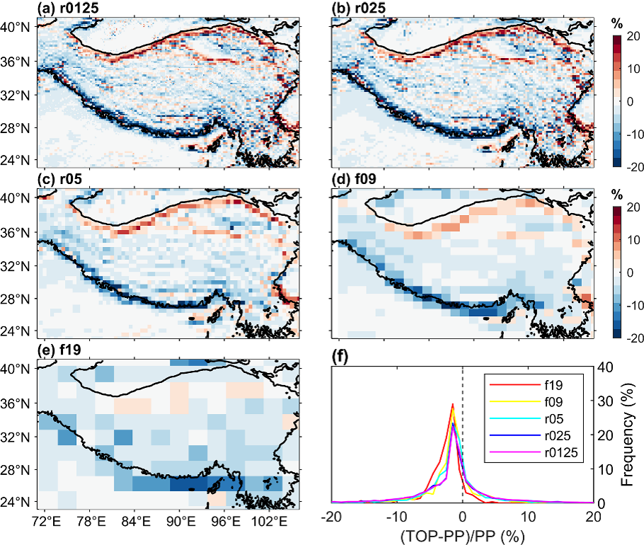
Figure 1. The relative differences of land surface albedo between TOP and PP schemes in winter at different spatial scales (a–e, ranging from 0.125—2 degrees) and the statistical histogram of their frequency distributions (f). The sub-grid topographic effects are stronger at higher spatial resolutions.
Summary
Topography significantly influences incoming solar radiation at the land surface. However, nearly all the ESMs that participated in the Coupled Model Intercomparison Project (CMIP6) use a plane-parallel (PP) radiative transfer scheme and assume that the terrain is flat. This study incorporated a well-validated sub-grid TOP scheme in the ELM to quantify the effects of sub-grid topography on solar radiation flux. The results show that topography has non-negligible effects on the modeled surface energy budget, snow cover, snow depth, and surface temperature over the Tibetan Plateau. The magnitude of the sub-grid topographic effects (Fig. 1) depends on the season, elevation, and spatial scale. When compared to remote sensing data, incorporating the TOP reduces ELM’s biases for simulating surface energy balance, snow cover, and surface temperature, especially for high-elevation and snow-covered regions. This study underscores the importance of representing sub-grid topographic effects in ESMs and motivates future research to understand sub-grid topographic effects on terrestrial processes over mountainous areas.
Publication
Hao, D., Bisht, G., Gu, Y., Lee, W.-L., Liou, K.-N., and Leung, L. R. “A parameterization of sub-grid topographical effects on solar radiation in the E3SM Land Model (version 1.0): implementation and evaluation over the Tibetan Plateau”, Geosci. Model Dev., 14, 6273–6289, (2021), DOI: 10.5194/gmd-14-6273-2021
Funding
- The U.S. Department of Energy Office of Science, Biological and Environmental Research Program supported portions of this research as part of the Regional and Global Model Analysis (RGMA), Atmospheric System Research (ASR), and Earth System Model Development (ESMD) program areas.
- This research used resources of the National Energy Research Scientific Computing Center (NERSC).
- This research has been supported by the Department of Energy, Office of Science, Biological and Environmental Research program, Earth System Model Development program area, by the U.S. National Oceanic and Atmospheric Administration, and by the National Science Foundation.
Contact
- Gautam Bisht, Pacific Northwest National Laboratory
- L. Ruby Leung, Pacific Northwest National Laboratory
This article is a part of the E3SM “Floating Points” Newsletter, to read the full Newsletter check: