

Dynamic Ice Sheets & Regional Sea-Level Change Projections in E3SM
Key Points
- Efforts across the E3SM ecosystem are building towards a unified and integrated sea-level change capability. Regional sea-level change projected by E3SM brings together sea-level contributions from changes to ocean density and currents, meltwater input from ice sheets, and gravitational, rotational, and deformation effects of the solid Earth.
- E3SM’s ice-sheet component, MPAS-Albany Land Ice (MALI), is a mature, variable resolution, high-fidelity ice-sheet model with advanced optimization and uncertainty quantification capabilities and performance portability for effective use of mixed CPU and GPU computing architectures. MALI is the first large-scale ice-sheet model to routinely run on GPUs, including a recent 72-member ensemble of the Antarctic Ice Sheet at 4 km resolution.
- Coupling for both the Antarctic and Greenland Ice Sheets is nearing completion to both the land (snowpack model) and ocean components of E3SM.
Background
Sea level has risen by about 20 cm since 1900, primarily in recent decades, but future projections are highly uncertain, ranging from 40 cm to well over 1 meter by 2100, with extreme scenarios of over 15 m by 2500. Changes in sea level are caused by changes in ocean density change (e.g., thermal expansion) and changes in ocean mass, primarily due to the growth or decay of ice sheets and mountain glaciers, with additional factors affecting regional sea-level variations (Figure 1). To date, projections of sea-level change have been made by adding together these disparate contributors to sea level, most often using different combinations of models and analyses to derive the necessary sets of inputs. Generally, the ocean sterodynamic change – the net effect on sea surface height from ocean density changes and changes in ocean circulation – is the only component of sea-level change that can be evaluated using outputs from most Earth system models, including E3SM. To improve upon these limitations, efforts from across the E3SM ecosystem projects have made substantial progress towards a unified treatment of sea level change within E3SM.
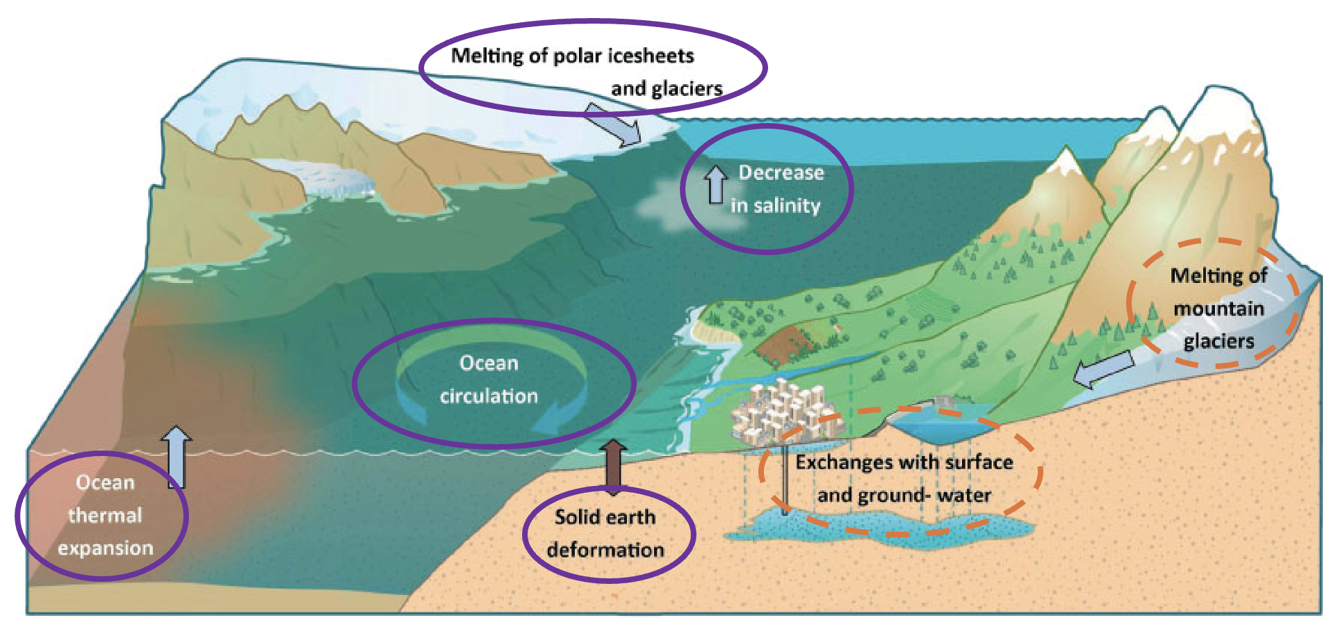
Figure 1: Processes contributing to sea-level change. Purple ovals indicate processes being accounted for in E3SM through current development. Orange dotted ovals indicate other processes remaining to be addressed. (Figure modified from Cazenave and Cozannet (2014)
E3SM’s GPU-accelerated ice-sheet component, MPAS-Albany Land Ice (MALI)
While Ice sheets have the potential to be the largest contributors to future sea level change, that future evolution is highly uncertain. Therefore, the inclusion of an ice-sheet model component is a critical element for projecting future sea level change within an Earth system modeling framework. E3SM’s ice-sheet model component, MPAS-Albany Land Ice (MALI; Hoffman et al., 2018), is a high-fidelity, variable-resolution ice-sheet model that accounts for all of the necessary physical processes, including ice dynamics, thermodynamics, iceberg calving, subglacial processes (e.g., sliding, hydrology), and glacial isostatic adjustment, as well as advanced optimization and initialization. MALI is currently primarily developed under the Framework for Antarctic System Science in E3SM (FAnSSIE) SciDAC project, building on work from previous SciDAC projects (ProSPect, PISCEES) and E3SM.
MALI is robust, highly scalable (to O~104 processors), and performance portable on DOE hybrid CPU+GPU architectures (Watkins et al. 2023). MALI’s velocity solver leverages the Kokkos programming model through the Albany and Trilinos C++ software frameworks to achieve performance portability across a range of supercomputing architectures (Figure 2). MALI GPU utilization has been demonstrated on both Perlmutter and Frontier, highlighting its readiness for exascale supercomputers. To our knowledge, MALI is the first large-scale ice-sheet model to routinely run on GPUs, including a recent 72-member ensemble of the Antarctic Ice Sheet at 4 km resolution.

Figure 2: MALI’s Greenland Ice Sheet configuration in E3SM. Left: For the Greenland Ice Sheet, the grid size coarsens from 1km in fast-flowing outlet glaciers (inset) to 10 km in the slow-flowing interior. Upper right: MALI performance on GPUs on both Perlmutter and Frontier scale to 108 unknowns. Lower right: Cost of the high-resolution Greenland component (GLC region in pink) is minor in a fully-coupled E3SM simulation.
Recently, MALI produced projections of the Antarctic Ice Sheet through 2300 as part of the Ice Sheet Model Intercomparison for CMIP (ISMIP), which included 16 ice-sheet models running a series of 15 experiments (Seroussi et al., 2024). The MALI configuration (Figure 2) was among the ice-sheet models with the highest resolution, the highest-fidelity ice dynamics solver, and the best match to historical trends. While MALI projects the sea-level contribution from Antarctica through 2100 to be between 2 centimeter fall and 11 centimeter rise under high greenhouse gas emissions scenarios, through 2300 the sea-level contribution rises to between 0.8 and 2.8 meters. This range increases to 2.4–3.9 m when including a parameterization of ice-shelf hydrofracture (a process whereby ice shelves rapidly collapse following atmospheric warming and meltwater ponding on the surface).
Figure 2. Projection of the Antarctic Ice Sheet through 2300 forced by CMIP6 output under a high greenhouse gas emissions scenario as simulated by MALI. Purple colors indicate ice-sheet flow speed (darker=faster flow), red colors indicate surface melting, blue colors indicate ocean temperature, and orange colors indicate ocean-driven basal melting of floating ice.
Projections remain highly uncertain, and a significant amount of that uncertainty comes from poorly-known ice-sheet model parameters. To address this challenge, uncertainty quantification methods developed by the FAnSSIE project have recently been used to produce probabilistic projections for a single sector of the Antarctic Ice Sheet. By combining ensembles of hundreds of MALI simulations with statistical emulation to calibrate model parameters to historical glacier observations, this study found that the Amery Ice Shelf sector of East Antarctica is likely to increase future sea level from this region in the range of 5-13 centimeters through 2300 (Figure 3; Jantre, et al. 2024). While this sector was previously believed to be relatively stable on century timescales, our results show that it is susceptible to the impacts of submarine melting if warm ocean currents are able to reach the floating ice shelf, an ocean regime shift that occurs under high emissions scenarios.
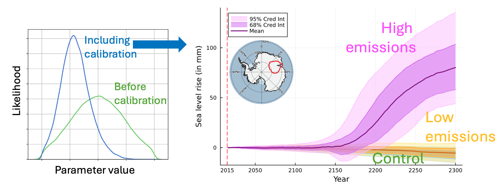
Figure 3: MALI model calibration to enable probabilistic projections of sea-level contribution from the Amery Ice Shelf sector of Antarctica under low and high greenhouse gas emissions scenarios
Coupling of MALI to E3SM
Coupling of MALI to E3SM is nearing completion, which will: 1) provide more accurate representations of atmospheric and oceanic forcing to the ice sheets, 2) account for and more fully understand the feedbacks between ice sheets and other parts of the Earth system, and 3) produce self-consistent projections of sea level that are currently not possible with Earth system models. This work is proceeding for both the Greenland and Antarctic ice sheets, with the Greenland effort primarily occurring under E3SM and different elements of the Antarctic effort occurring under E3SM and the FAnSSIE project. Interactions between ice sheets and other components of the Earth system occur at the ice-sheet upper surface (represented in E3SM via coupling with the land component, which lies between the ice sheet and the atmosphere) and with the lower surface of the floating regions of the ice sheet (represented via coupling with the ocean component). Recent work has made substantial progress on establishing the necessary coupling between MALI and these these other components for both the Greenland (Figure 4) and Antarctic (Figure 5) ice sheets.
MALI coupling to E3SM’s atmosphere and land
The atmosphere interacts with ice sheets primarily through the addition or subtraction of mass at its surface (mainly from snowfall and melting, respectively), which is controlled by the surface energy balance. In E3SM, this occurs within the snowpack model in the E3SM Land Model (ELM). However, because the thin seasonal snowpack that occurs over much of Earth’s surface is not appropriate for simulating the deep (up to 100’s of meters) snowpacks on ice sheets, ELM’s snowpack model has been augmented to allow for up to 16 layers and a maximum snow depth of 60 meters water equivalent over ice sheets (relative to 5 layers and 1 meter for seasonal snow cover) (Schneider, et al., 2022, 2023). Additional improvements have added compaction of deep snow and the percolation of meltwater into the snowpack, processes necessary to simulate the transition of new snow to glacial ice over time. This development has allowed for a realistic present-day representation of the snowpack over ice sheets, generated by spinning-up the snowpack model over 1000 years (to approximate equilibrium) followed by several decades of historically-constrained ERA5 reanalysis forcing. With these improvements, E3SM now produces Greenland and Antarctic ice sheet “surface mass balance” that compares well with observations as well as state-of-the-art regional models, like RACMO and MAR (Figures 4 and 5). E3SM v3 simulations with active surface mass balance coupled to a dynamic MALI configuration of Greenland are currently undergoing testing (Figure 4) and scientifically supported configurations are expected to be available later this year.

Figure 4: Overview of active development for the coupling a dynamic Greenland Ice Sheet component to E3SM. References in blue refer to presentations at the 2024 Fall AGU meeting.
MALI coupling to E3SM’s ocean
The ocean and ice sheets interact where large outlet glaciers terminate directly in the ocean (as occurs primarily in Greenland) or where the ocean circulates beneath large floating ice shelves (as occurs primarily in Antarctica). In both cases, warm ocean currents can result in substantial melting of floating ice, changing the balance of forces at the ice-sheet margins and impacting the dynamics of inland ice flow.
Significant progress has been made in coupling MALI to E3SM’s ocean component, MPAS-Ocean. While E3SM has had the ability to simulate circulation in the cavities beneath floating ice shelves and ice shelf basal melting since version 1 (Comeau et al., 2022; Figure 5), the cavity shapes were required to be static. To allow for expansion or reduction of these cavities as the ice sheet evolves, the existing coastal inundation capability of MPAS-Ocean has now been extended from a single column implementation to the full, 3d, realistic ocean configuration used in E3SM. Imposed advance and retreat of cavity boundaries has now been realized in idealized configurations, and work is in progress to generalize this capability to realistic E3SM configurations (Figure 5). Additionally, the subglacial discharge from beneath the Antarctic Ice Sheet has been introduced into the ocean cavities in global E3SM simulations, where it locally increases ice-shelf basal melt rates (Vaňková et al., 2025). Completion of ice-sheet/ocean coupling for Antarctica with dynamic ocean cavities is planned for 2026. However, coupled ice-sheet/ocean simulations are starting early 2025 using a simplified ocean coupling scheme based on ocean temperature and which allows for ice-shelf evolution in MALI while keeping cavity geometry in MPAS-Ocean static.
In Greenland, where outlet glaciers terminate in submarine cliffs rather than ice shelves, narrow fjords (several kilometers wide) are too small to be fully represented in the ocean model. Coupling to the ocean will occur by passing the nearest ocean temperatures to a submarine melt parameterization in MALI (e.g., Hillebrand et al., 2022), enabling the Greenland Ice Sheet to respond to changing ocean conditions. This coupling has been recently added to E3SM and its evaluation is underway, including assessment of parameterizations that account for processes unique to Greenland’s fjords (Hager et al. 2024), such as iceberg melting and blocking of deep water masses by shallow sills (Figure 4). Completion of this coupling and initial E3SM simulations with a coupled 1-to-10 km Greenland Ice Sheet component are planned for this quarter.

Figure 5: Overview of active development for coupling a dynamic Antarctic Ice Sheet component to E3SM. References in blue refer to presentations at the 2024 Fall AGU meeting.
Self-consistent sea-level change in E3SM
As described above, while ice sheets constitute the largest uncertainty in sea-level projections, there are multiple contributors to sea level (Figure 1). As part of the Sea-Level Enabled E3SM DOE Early Career Research project, analysis tools have been created to evaluate the sterodynamic sea-level changes (effect on sea surface height from ocean density changes and changes in ocean circulation) simulated by MPAS-Ocean for the first time. In addition to regional variations in steric and dynamic sea level, regional variations in sea level are also caused by deformation of the solid Earth, gravitational changes, and changes to the Earth’s rotation as ice and water mass are redistributed around the Earth’s surface. A tool to evaluate these regional effects on sea level has also been prototyped and will be added to E3SM post-processing workflows, anticipated for the end of 2025 (Figure 6). To fully complete the E3SM sea-level budget, future work will also need to introduce a component for mountain glaciers and icecaps and to add analysis of changes in the water stored in lakes, reservoirs, and groundwater, but the most uncertain sea-level contributors are already accounted for.
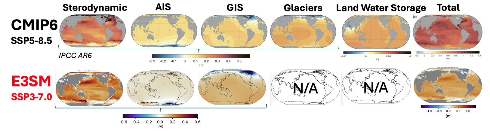
Figure 6: Regional sea-level change between 2015 and 2100 evaluated from the E3SM v2.1 Polar configuration. That Antarctic Ice Sheet (AIS) contribution comes from a standalone MALI simulation forced by ocean conditions from the E3SM projection. The Greenland Ice Sheet (GIS) contribution comes from a standalone MALI simulation forced by CMIP5 data. The AIS and GIS sea-level change maps from E3SM include gravitational, rotational and deformation effects on the sea-level equipotential surface globally, which is why those plots show sea-level changes over land, in addition to the ocean.
Taken together, the maturation of the MALI ice-sheet model, the coupling of MALI to E3SM’s land and ocean components, and the tools for regional sea-level analysis position E3SM to be among the first Earth system models to project sea level change in a fully-coupled and internally consistent manner.
Funding
MALI development is currently supported by the Framework for Antarctic System Science in E3SM (FAnSSIE) SciDAC project and the E3SM project, building on work from previous SciDAC projects ProSPect and PISCEES. Coupling of MALI to E3SM for the Greenland Ice Sheet is supported by the E3SM project, while coupling for the Antarctic Ice Sheet is led by the FAnSSIE project, in close coordination with E3SM. Regional sea-level capabilities are being developed as part of the Sea-Level-Enabled E3SM Early Career Research project. These activities are sponsored by the U.S. Department of Energy, Office of Science, Office of Biological and Environmental Research, Earth System Model Development program area of Earth and Environmental System Modeling, and Office of Science Advanced Scientific Computing Research program.
References
- Comeau, Darin, Xylar S. Asay‐Davis, Carolyn Branecky Begeman, Matthew J. Hoffman, Wuyin Lin, Mark R. Petersen, Stephen F. Price, et al. 2022. “The DOE E3SM v1.2 Cryosphere Configuration: Description and Simulated Antarctic Ice‐Shelf Basal Melting.” Journal of Advances in Modeling Earth Systems 14 (2). https://doi.org/10.1029/2021MS002468.
- Hager, Alexander O., David A. Sutherland, and Donald A. Slater. 2024. “Local Forcing Mechanisms Challenge Parameterizations of Ocean Thermal Forcing for Greenland Tidewater Glaciers.” The Cryosphere 18 (2): 911–32. https://doi.org/10.5194/tc-18-911-2024 .
- https://doi.org/10.5194/tc-16-4679-2022 .
- Hoffman, Matthew J., Mauro Perego, Stephen F. Price, William H. Lipscomb, Tong Zhang, Douglas Jacobsen, Irina Tezaur, Andrew G. Salinger, Raymond Tuminaro, and Luca Bertagna. 2018. “MPAS-Albany Land Ice (MALI): A Variable-Resolution Ice Sheet Model for Earth System Modeling Using Voronoi Grids.” Geoscientific Model Development 11 (9): 3747–80. https://doi.org/10.5194/gmd-11-3747-2018.
- Jantre, Sanket, Matthew J. Hoffman, Nathan M. Urban, Trevor Hillebrand, Mauro Perego, Stephen Price, and John D. Jakeman. 2024. “Probabilistic Projections of the Amery Ice Shelf Catchment, Antarctica, under Conditions of High Ice-Shelf Basal Melt.” The Cryosphere 18 (11): 5207–38. https://doi.org/10.5194/tc-18-5207-2024.
- Schneider, Adam M., Charles S. Zender, and Stephen F. Price. 2022. “More Realistic Intermediate Depth Dry Firn Densification in the Energy Exascale Earth System Model (E3SM).” Journal of Advances in Modeling Earth Systems 14 (3). https://doi.org/10.1029/2021MS002542.
- Schneider, Adam, Charles Zender, Nicole Loeb, and Stephen Price. 2023. “Use of Shallow Ice Core Measurements to Evaluate and Constrain 1980–1990 Global Reanalyses of Ice Sheet Precipitation Rates.” Geophysical Research Letters 50 (19): e2023GL103943. https://doi.org/10.1029/2023GL103943 .
- Seroussi, Hélène, Tyler Pelle, William H. Lipscomb, Ayako Abe-Ouchi, Torsten Albrecht, Jorge Alvarez-Solas, Xylar Asay-Davis, et al. 2024. “Evolution of the Antarctic Ice Sheet Over the Next Three Centuries From an ISMIP6 Model Ensemble.” Earth’s Future 12 (9): e2024EF004561. https://doi.org/10.1029/2024EF004561.
- Watkins, Jerry, Max Carlson, Kyle Shan, Irina Tezaur, Mauro Perego, Luca Bertagna, Carolyn Kao, Matthew J Hoffman, and Stephen F Price. 2023. “Performance Portable Ice-Sheet Modeling with MALI.” The International Journal of High Performance Computing Applications 37 (5): 600–625. https://doi.org/10.1177/10943420231183688.
- Vaňková, I., Asay-Davis, X., Branecky Begeman, C., Comeau, D., Hager, A., Hoffman, M., Price, S. F., and Wolfe, J.: Subglacial discharge effects on basal melting of a rotating, idealized ice shelf, The Cryosphere, 19, 507–523, https://doi.org/10.5194/tc-19-507-2025 , 2025.
Presentations at American Geophysical Union 2024 Annual Meeting
- Begeman, C. Simulating grounding zone ice-shelf and ocean interactions in the Energy Exascale Earth System Model
- Comeau, D. Projections of Antarctic sub-ice-shelf melting through 2100 with the Energy Exascale Earth System Model
- Hager, A. Greenland Ice Sheet mass loss projection uncertainty arising from ocean forcing parameterizations
- Muruganandham, S. Towards an Antarctic Ice Sheet Large Ensemble
- Nolan, A. Sensitivity of projections of the Greenland Ice Sheet to 2100 to basal friction and calving parameters
- Price, S. Development and Testing of a Coupled Greenland Ice Sheet Component in E3SM
- Shafer, C. Antarctic Ice Sheet response to modeled and parameterized ice-shelf melt rates from an Earth system model with ice-shelf cavities
- Vaňková, I. Subglacial discharge effects on ice-shelf basal melting in Antarctica
- Whicker Clarke, C. Analyzing Surface Mass Balance from E3SM Against RACMO and Observational Data
This article is a part of the E3SM “Floating Points” Newsletter, to read the full Newsletter check: