

Expanding Irrigation Increases Regional Land Water Depletion
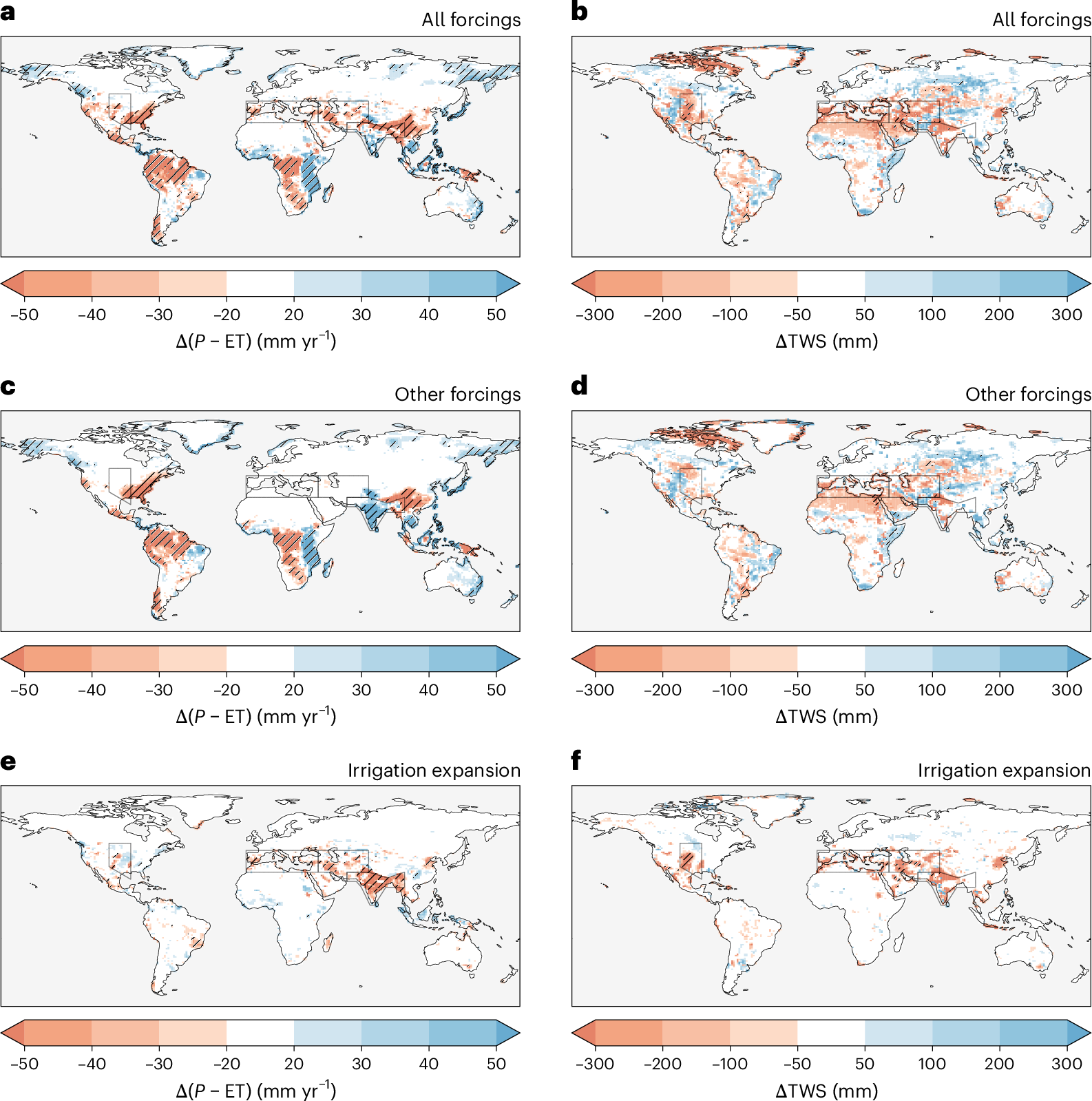
Figure 1. Comparison of the modeled impacts of combined drivers (a,b), non-irrigation drivers (c,d) and irrigation expansion (e,f) on net atmospheric water input (precipitation minus evapotranspiration [P – ET]) (a,c,e) and terrestrial water storage (TWS) (b,d,f). Widespread declines can be seen in regions with substantial irrigation growth. See paper figure 3 for full details.
Modeling showed that irrigation growth accelerated freshwater losses from land, especially where water is already limited.
The Science
Irrigation requires large water inputs, which can reduce long-term water availability and put stress on nearby systems. However, many earlier studies have failed to fully capture how drawing water for irrigation alters exchanges between land and atmosphere over long time periods.
The Impact
This study is among the first to show, using multiple Earth system models (ESMs) with evolving irrigation patterns, that irrigation growth can accelerate the depletion of water stored on land. This helps clarify how irrigation reshapes long-term land-atmosphere water exchange and terrestrial storage, especially in regions where freshwater is limited. The study’s approach was distinct because it isolated irrigation effects from other drivers across more than a century, which offers new insight into how long-term farming practices alter land water stores. The findings highlight that irrigation fundamentally alters surface water balance through persistent enhancement of evapotranspiration without a compensating increase in precipitation. Irrigation was found to notably contribute to depletion in several major food-producing regions, which can inform future Earth system science, hydrology, and land-surface process studies that investigate how water use interacts with land-atmosphere feedbacks.
Summary
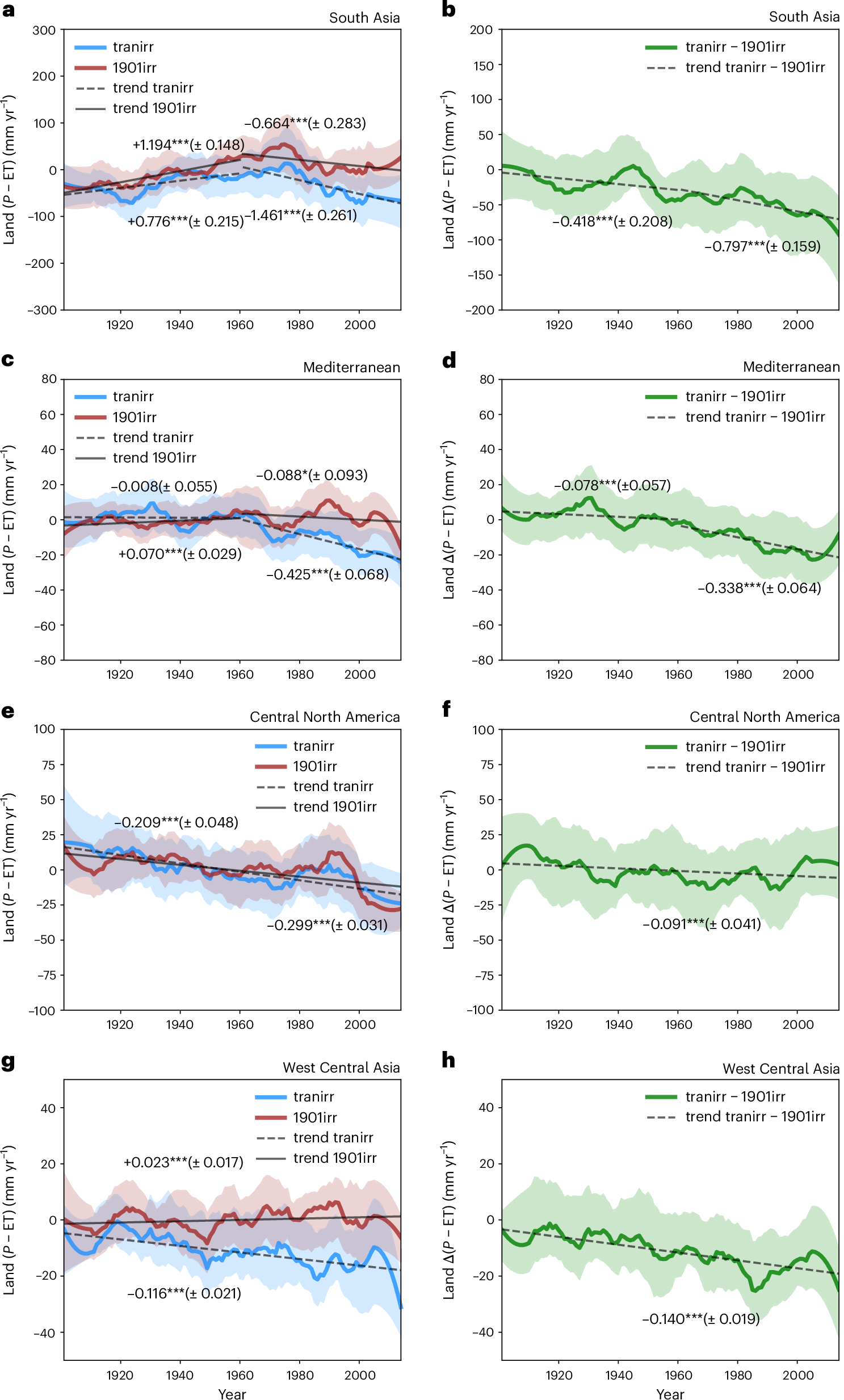
Regionally averaged annual land water balance (precipitation minus evapotranspiration [P – ET]) anomaly from both simulations with (tranirr) and without irrigation expansion (1901irr) and the difference between them (tranirr − 1901irr) over South Asia (a,b), the Mediterranean (c,d), Central North America (e,f) and West Central Asia (g,h). The figure shows how irrigation altered net atmospheric water input over time, with consistent declines in land water availability in heavily irrigated regions. See paper figure 4 for full details.
Researchers used seven ESMs, including the U.S. Department of Energy’s Energy Exascale Earth System Model (E3SM), to evaluate how the worldwide rise in irrigation from 1901 to 2014 changed water movement between land and the atmosphere. They compared scenarios with and without irrigation expansion to measure its direct influence on water storage, including soil moisture and groundwater. Expanding the irrigated area increased water withdrawals over time, particularly in South Asia, the Mediterranean, western Central Asia, and Central North America. These regions experienced higher evapotranspiration, meaning more water moved back into the air. In most cases, this increase in water loss from the land surface was not compensated for by higher rainfall, decreasing net atmospheric water input to land and land water storage, including soil moisture and groundwater (Fig. 1). The simulations showed that irrigation expansion steepened downward trends in land water storage, especially after the mid-twentieth century. This pattern was most notable where groundwater use was represented in the model, highlighting the importance of modeling underground water extraction. Regions with drier conditions, including western Central Asia and South Asia, experienced the largest storage declines (Fig. 2). Independent satellite estimates from GRACE were consistent with simulated land water declines.
Publication
- Yao, Y. et al. Irrigation-induced land water depletion aggravated by changing global conditions. Nat. Water (2025). https://doi.org/10.1038/s44221-025-00529-1
Funding
- TZ and LRL were supported by the Office of Science, U.S. Department of Energy, Biological and Environmental Research (BER) through the Regional and Global Model Analysis Program area as part of WACCEM and through the Earth System Model Development Program Area as part of E3SM.
Contact
- L. Ruby Leung, Pacific Northwest National Laboratory
This article is a part of the E3SM “Floating Points” Newsletter, to read the full Newsletter check:
- E3SM Floating Points, May ’26: Looking Forward to the Summer All-Hands
