

Zooming In: SCREAM at 100 m Using Regional Refinement over the San Francisco Bay Area
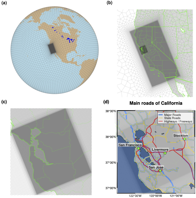
Figure 1. The regionally refined grid for (a) global view, (b) California view, (c) Bay Area view, and (d) Bay Area overlaid with roads in the 100 m SCREAM-RRM.
Pushing a global atmosphere model into the large-eddy simulation (LES) resolution range, especially over complex terrain, has long felt out of reach. LES studies at ~100 m grid spacing have delivered transformative insight into turbulence, orographic flows, and coastal cloud systems, but they are typically run in idealized or limited-area configurations that do not fully reflect the coupled physics and conservation constraints of a comprehensive Earth system model. In a newly accepted paper, E3SM researchers demonstrate a major step toward closing that gap by running SCREAM (the Simple Cloud-Resolving E3SM Atmosphere Model) at 100 m horizontal resolution within a regionally refined mesh (RRM) over the San Francisco Bay Area. To the team’s knowledge, this represents the first time a global model has been pushed to such fine spatial scales.
Their experimental design pairs a California-wide refined mesh (~800 m) with an embedded 100 m refinement spanning roughly 150 × 150 km^2 over the Bay Area, large enough to capture rich terrain–coastline interactions while still benefiting from the global model’s consistent dynamics, physics, and boundary conditions (Fig. 1). They evaluated the configuration using two contrasting two-day hindcasts: a 2008 bomb cyclone (strong synoptic forcing) and a 2023 Marine Layer Intrusion event (weak synoptic forcing with a pronounced diurnal boundary layer). Across both cases, SCREAM runs stably at 100 m while interacting with realistic topography (Fig. 2), land heterogeneity, and coastal geometry, demonstrating that RRM technology can deliver LES-scale resolution where it matters without requiring a globally uniform 100 m simulation.
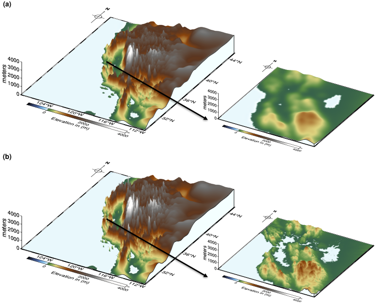
Figure 2. The topography of the (a) 3.25 km California RRM and (b) 100 m Bay Area RRM. Each is shown with both a full California overview and a bird’s-eye view of the Bay Area.
The scientific payoff is immediate and tangible. Relative to the baseline 3.25 km California RRM, the 100 m Bay Area simulation substantially improves near-surface meteorology across dense in-situ networks, including wind speed, temperature, humidity, and surface pressure. During the 2008 bomb cyclone, the 100 m configuration markedly reduces the familiar high wind-speed bias and produces more realistic fine-scale temporal variability, including high-frequency wind oscillations that align closely with coastal observations. In the 2023 Marine Layer Intrusion case, the 100 m run better captures the nocturnal inland expansion and daytime coastal retreat of marine stratus, improving the local thermodynamic evolution that shapes Bay Area weather patterns. One reason this “just works” at 100 m without special tuning (for example: adjusting turbulence length scales, mixing coefficients, or regime-dependent parameters to get the simulation to run) is that SHOC is inherently scale-aware, allowing SCREAM’s turbulence representation to transition smoothly as resolution increases.
It’s also important to clarify what is meant by “LES-scale.” In the paper, the authors emphasize that SCREAM is operating at LES resolutions, but they do not label the configuration as a full LES model in the strict sense because SCREAM does not yet include a turbulence closure that includes subgrid horizontal mixing as a process. That capability is now actively under development, and they do not anticipate major changes to the overall solution once 3D turbulence is introduced; rather, it is expected to strengthen SCREAM’s physical foundation in the turbulence gray zone (the transitional range of scales where motions are only partly resolved) and at ~100 m. With that addition, SCREAM will be positioned to provide true LES capability within a comprehensive global modeling framework.
The paper also highlights what it will take to make this capability broadly usable. At 100 m, stability hinges on careful treatment of topography and time stepping, and the workflow required key improvements to the E3SM toolchain (including addressing interpolation corner cases and adopting more aggressive topographic smoothing for robust nonhydrostatic runs). Performance is the other major story: CPU-only simulations remain extremely expensive, but GPU acceleration changes the equation. Using SCREAMv1 (EAMxx) on NERSC’s Perlmutter system, the team demonstrates GPU-accelerated throughput of roughly one simulated day per day (1 SDPD) at 100 m resolution, an order-of-magnitude improvement over the ~0.16 SDPD achieved on CPU-only systems, reducing a two-day hindcast to under two wall-clock days and turning “hero runs” into a more practical experimental tool. Taken together, these advances position LES-scale SCREAM-RRM as a new platform for DOE-relevant applications, from wind-energy resource assessment and terrain-driven local atmospheric variability to coastal cloud processes and high-impact weather in complex regions. With continued improvements in topography preprocessing, initial-condition fidelity, numerical robustness, and with GPUs as the enabling technology, this work opens the door to a new era of global-model LES studies with SCREAM that were simply not feasible before.
Reference
Zhang, J., Bogenschutz, P., Taylor, M., and Cameron-Smith, P.: Zooming in: SCREAM at 100 m using regional refinement over the San Francisco Bay Area, Geosci. Model Dev., 19, 795–826, https://doi.org/10.5194/gmd-19-795-2026 , 2026.