New NCO Release Supports Vertical Regridding
![]()
The netCDF Operators (NCO) toolkit allows researchers to manipulate and analyze data stored in netCDF-accessible formats, including DAP, HDF4, and HDF5. Users can work with shell commands or flexible scripts to manipulate gridded and unstructured scientific data interactively.
The latest version 4.8.1 “INDICES” features vertical regridding functionality to support two key E3SM applications: (1) creating initial conditions for simulations with new vertical grids, and (2) converting native atmospheric model output to pressure-level output. First, developers of E3SM’s progenitor CESM use a tool called interpic to interpolate initial conditions to new (horizontal and) vertical grids. However interpic does not support vertical interpolation of data stored on the E3SM Atmosphere Model’s (EAM’s) innovative unstructured (native) horizontal grid. NCO authors extended the software’s ncremap command to permit vertical interpolation of atmospheric data in hybrid sigma pressure coordinates (used by EAM, CAM, and ECMWF) between any desired vertical grids. EAM developers use this feature to downscale ECMWF IFS forecast data to next-generation EAM ne512 and ne1024 grids. ncremap automatically extrapolates state variables to subterranean gridpoints using nearest-neighbor interpolation by default, and uses hydrostatic and hypsometric approximations for temperature and geopotential, respectively.
Secondly, E3SM EAM participates in model-intercomparison projects (MIPs) that request data on pure (not hybrid) pressure levels. Interpolating native output time series from hybrid to pure pressure levels was previously a time-consuming bottleneck for data preparation workflows, including CMIP6.

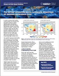
Vertical profiles of specific humidity (Q) at the equator before (a) and after (b) vertical regridding to get E3SMv1 data into the format required by CMIP6.
Panel (a) of the figure above shows a vertical cross-section of specific humidity (Q) at the equator (0 degrees latitude) from the E3SMv1 model which has 72 vertical pressure levels (in units of hectopascals – hPa). Panel (b) shows this same data regridded using NCO to comply with the CMIP6 standard which has 19 pressure levels (in pascals – Pa) and removes the atmospheric data where land exists (black means no data). The black area from ~50 W to ~80 W is South America with the higher “peak” slightly north of the city of Quito in Ecuador in the Northern Andes Mountains. The black area around 120 E is near the Indonesian islands, and the area covering 30 E is Africa with the highest black area at ~37.5 E which is on the northern flank of Mount Kenya at about 2,700 meters (~8,860 ft) elevation.
NCO uses OpenMP to parallelize vertical regridding over variables with the same style of options and arguments as horizontal regridding, and supports MIPs that prefer extrapolation to missing values rather than to nearest neighbors. Adding _FillValue attributes to an existing variable requires an extra file copy unless done during file definition, so NCO pre-screens input and output pressure fields to circumvent this situation.
Finally, NCO defines the vertical grid using a format much simpler than that for horizontal grids. Vertical grid files can be just a single variable for pressure grids, or as few as five variables for hybrid sigma pressure grids. These vertical gridfiles are both compact and easy to generate from scratch or infer from existing datasets. With both horizontal and vertical regridding features, ncremap now supports intercomparison of most models and observational grids.