Initial Land Use/Cover Distribution Affects Global Carbon and Local Temperature Projections
Initial land cover uncertainty contributes to carbon and temperature uncertainties.
The Science
International modeling efforts aim to understand global change and its impacts on humans and the environment. Modeling how human activities change vegetation (e.g., forest to cropland), and subsequently the greater environment, is difficult and highly uncertain, yet crucial to understanding impacts of global change. Sources of uncertainty in this context that have received little attention include the land change data, how these data are translated for use by a model, and how a model represents and implements land change. These uncertainties generate larger challenges for scenario-driven modeling and multi-model assessment in that they culminate in each model simulating a unique Earth, which reduces comparability and the potential for scientific consensus on understanding model results.

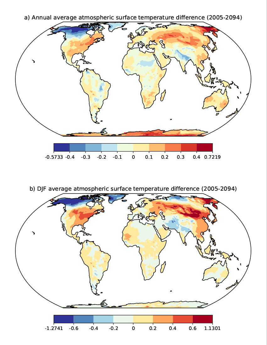
Figure 1. Persistent differences in 2005–2094 average annual (a) and seasonal (b) atmospheric surface temperature (°C) as a result of the difference between estimated maximum and minimum initial forest cover. The maximum range in temperature across grid cells occurs during December–January–February (DJF) (b).
The Impact
Understanding how land data uncertainty affects Earth system projections in a single model provides insight to the potential range of related projection uncertainties across multiple models and will advance implementation and understanding of multi-model comparisons. Using a single model provides the opportunity to isolate and assess a specific uncertainty, which in this case is the initial land cover distribution and its associated initial Earth state. Presenting the substantial effects of a single source of uncertainty in a controlled environment will provide impetus for widespread quantification of land change uncertainty. Increased understanding of how specific land representation affects Earth projections will facilitate the development of more capable models that can accommodate multiple land data and boundary conditions for both exploring uncertainty and for applying standards in multi-model comparison exercises.
Summary
Researchers used the integrated Earth System Model (iESM; v1.0), which is a version of the Community Earth System Model (CESM) that allows for variability in land conversion assumptions, to show that initial land cover uncertainty substantially affects future projections of carbon and temperature. Under a Representative Concentration Pathway 4.5 experiment, scientists estimated that an uncertainty range in year 2005 global forest of 3.9 x 10⁶ km2 (9-14% of the total forest area) generated an uncertainty of 6 ppmv in atmospheric carbon dioxide (CO2) concentration that increased to 9 ppmv by 2095 (a 50% increase in uncertainty). Similarly, the 2005 uncertainty in terrestrial carbon associated with land cover uncertainty was 26 Pg C, and this uncertainty increased to 33 Pg C by 2095. Furthermore, local surface temperature uncertainties ranged from -0.57 to 0.72 °C and persisted throughout the 21st century. Figure 1 shows the persistent, 90-year average differences in local surface atmospheric temperature which exist both annually (a) and seasonally (b), with the maximum range across grid cells occurring during December–January–February (DJF).
Publication
- Di Vittorio, A, X Shi, B Bond-Lamberty, K Calvin, and A Jones. 2020. “Initial Land Use/Cover Distribution Substantially Affects Global Carbon and Local Temperature Projections in the Integrated Earth System Model.” Global Biogeochemical Cycles 34(5). https://doi.org/10.1029/2019gb006383.
Funding
- The U.S. Department of Energy Office of Science, Biological and Environmental Research supported this research as part of the Earth System Modeling Program Area through the Energy Exascale Earth System Model (E3SM) project.
Contact
- Alan Di Vittorio, Lawrence Berkeley National Laboratory


